Course description
Introduction
Disaster is a sudden adverse or unfortunate extreme event- natural or man-made, which causes great damage to human beings as well as plants and animals. It occurs rapidly, instantaneously, and indiscriminately that exceed the tolerable magnitude within given time limits, make human adjustment difficult, result in catastrophic losses of property, lives and income, and become the headlines of different news media at national and global levels. Natural disasters are those events or accidents that occur very rarely and aggravate environmental processes to cause human miseries. Natural disasters like floods, cyclones, storm surges, river bank erosions, droughts, etc. are occurring across the globe at an alarming rate, causing severe loss of human lives, crops, livestock, properties and physical infrastructure.
Bangladesh is one of the most disaster-prone countries in the world. The geographical setting makes the country vulnerable to natural disasters. The lofty Himalays in the north and the funnel-like shape of the Bay of Bengal in the south, together with tropical monsoon climate have made Bangladesh an ideal home for natural hazards like foods, cyclones and storm surges. Various anthropogenic activities are also held responsible to worsen the situation. Excessive rainfall during monsoon and high average sea surface temperature during pre-monsoon and post-monsoon periods contribute to the hazardous situation. Further, effects of El-Nino Southern Oscillation (ENSO) and the possible climate change due to global warming will have great impact on the overall future disaster scenarios in Bangladesh.
This chapter devotes attention to natural disasters and discusses some of the major environmental hazards experienced in the country or elsewhere (e.g. tsunami, volcanic eruption etc.) highlighting their causes, impacts on the environment, management, and measures for mitigation. The major natural disaster that affects Bangladesh are many and varied, however, floods and cyclones (with accompanying storm surges) have been the most significant over the years. In fact, these extreme events have received more media attention because of the magnitude of loss of human lives, damage to property and the natural environment. The other disasters concerned here are the occurrences of river bank erosion, drought, earthquake and landslides.
A: Floods
Location and Geographic Condition: Floods are commonly labeled as unwanted inundation of land that can endanger people's lives, their property, domestic animals, damage crops, homesteads and infrastructure and disrupt economic activities. Indeed, floods are a recurrent phenomenon in Bangladesh. The geographical location of the country in the lower part of the Ganges-Brahmaputra-Meghna (GBM) river basins, together with the flat topographic nature of the terrain, and monsoon rains makes her extremely vulnerable to seasonal floods. The catchment area of the GBM river systems (1. 75 million sq km), comprising the northern slope of the Himalayas in Tibet of China, Northern India, Bhutan and Bangladesh is equivalent to the area of Bangladesh (1,48,000 sq. km) by dozen times. Heavy rainfall in the vast GBM catchment area and prolonged high rainfall within Bangladesh causes the rivers to overflow. The country provides the outlet for the GBM waters through the Lower Meghna estuary into the Bay of Bengal although only 7.5 percent of the GBM catchment area lies within the country. Bangladesh has no other choice but to drain water from the catchment area that is 12 times of its size. As a result of flat topography of the landmass, one-fifth to one-third of the country is usually flooded even in a year of normal precipitation. People living in the floodplains are accustomed to flood and their livelihood and agricultural practices have evolved with it, except when it exceeds normal level.
Causes: Floods in Bangladesh are caused by a combination of complex environmental factors. These are as follows:
· heavy water flows generated by intensive rainfall in the upland (upstream) catchment areas during pre-monsoon period; 93 percent of the total catchment area lie across the boarder;
· excessive siltation of the major river beds that have reduced their water carrying capacity; (drainage congestion due to siltation of river beds)
· a gentle slope gradient of the vast floodplain that prevents quick recession of excess water;
· huge water flows produced by monsoon rain and consequent over spilling of the major rivers;
· synchronization of peak flows in the GBM river systems, causing drainage congestion at the mouth (the Meghna confluence);
· high tide in the Bay of Bengal coupled with southwesterly monsoon winds cause obstruction to the drainages of upland discharge;
· failure of runoff that are produced by heavy local rainfall to quickly carry away water due to high stage in the outfall rivers; and
· storm surges due to tropical cyclones in the Bay of Bengal.
· improper structural development; and
· deforestation in upper catchment area
Types of Flood
In Bangladesh, four major types of floods- flash floods, rainwater (local) floods, monsoon (river) floods, and storm surges floods- are normally experienced, affecting various parts of the country with different duration and intensity. These are discussed as follows:
Flash Floods: The normal sequence of floods in Bangladesh begins with flash floods, characterized by sharp rise to the peak stage followed by rapid fall, and a characteristic feature of northeast and southeastern hill basins, particularly during the pre-monsoon months of April and May. Flash floods are caused by runoff during exceptionally heavy rainfall occurring in the neighbouring upland areas. The major rivers that generally experience flashflood are Purnabhaba, Karatoya, Dharla and Teesta in the north, Surma, Kusiyara, Kangsa, Manu and Khowai in the northeast, and Gumti, Muhuri, halda, and Matamuhuri in the southeast. A maximum rainfall of 10-day, exceeding 300 mm is considered to be an index of flash flood in any given area. The high velocity of flood water often damage crops and property including infrastructure (road, railway) and flood protection embankments. Croplands in the hill basins are often buries under sand carried by the flood water.
Monsoon Floods in the major rivers (including their tributaries and distributaries) are characterized by slow rise of water levels and gradual inundation of vast areas over several weeks through over-bank spilling. These floods are mainly caused by snowmelt in the High Himalayas, and intensive rainfall over the lofty ranges of the Himalayan Mountains, the Assam-Tripura hills, and the upper GBM floodplains outside Bangladesh. With commencement of the monsoon in June, the Brahmaputra and the Meghna normally reach peak stage in July and August, while floods in the Ganges occur in August and September. Overland flooding is particularly severe in years when high flood peaks of the GBM systems coincide, as it happened during the catastrophic floods of 1988. By nature, the intensity and duration of monsoon floods are also dependent upon the synchronization of flood peaks of major rivers and the tidal effects of the sea. Monsoon floods cause significant damage to crops, livestock, houses, roads and other infrastructure, and are also responsible for riverbank erosion. The crucial determinants of the extent of devastation from monsoon floods are its timing, depth and duration of stay.
Figure 16.1: An Image of Monsoon Flood in Bangladesh
Rainwater (Local) Floods: are caused by long-duration, high intensity rainfall within Bangladesh (occurring over the floodplains, terraces and hills) that generates runoff (water) volumes in excess of the drainage capacity. Damage to crops, houses, settlements, roads and other infrastructure are severe when rainwater floods (from intensive localized rainfall) coincide with peak river flows. The southeastern parts of the country frequently experience such tidal flooding.
Storm Surges: Storm surges are raised sea levels caused by a combination low air pressure and strong onshore winds associated with tropical cyclones. In fact, tropical cyclones are often accompanied by storm surges- elevated sea levels, causing sudden but temporary flooding in the coastal areas, are responsible for most of the deaths and devastation. The extent of storm surge floods depends on a number of factors such as the peak of the storm surge at the coast, the relief of the adjoining land, presence of coastal embankment, obstruction of water flow by settlements, trees, crops and roads.
Extent, Trend and Impacts of Floods
Extent and Trend: Bangladesh has been experiencing floods since historic time. A list of floods that occurred between 1870 and 1922 (in the area now constitute Bangladesh) is found in the report prepared by Mahalanabis (1927)- a professor, reputed statistician and meteorologists. However, no reliable statistics is available on floods for the period between 1923 and 1953. Since 1954, the floods in Bangladesh have been fairly recorded and are well understood. Generally, the floods that inundate over 33 percent of the country are labeled as catastrophic, while inundation between 25 and 33 in the same is defined as severe flood. The extent of floods and corresponding damages during the last haft of the 20th Century are shown in (Table 16.1)
Table 16.1: Extent of major flood and corresponding damages in Bangladesh, 1954 - 1998
Year | Inundated Area (sq. km) | % of Area Inundated | Damage (Million Taka) |
1954 | 36,778 | 25.55 | 1,200 |
1955 | 38,850 | 26.98 | 1,240 |
1956 | 35,883 | 24.64 | 2,180 |
1962 | 37,296 | 25.90 | 1,020 |
1963 | 35,224 | 24.46 | 83 |
1968 | 37,296 | 25.90 | 1,645 |
1970 | 36,260 | 25.18 | 330 |
1971 | 38,332 | 26.62 | 380 |
1974 | 38,850 | 26.98 | 10,000 |
1987 | 54,390 | 37.77 | 10,000 |
1988 | 43,994 | 58.33 | 50,000 |
1998 | 100,000 | 65.00 | 100.000 |
Source: Adapted through modification from Zohra, 1999 and Nishat et. al., 2001
The three most damaging floods that occurred in Bangladesh were floods in 1987, 1988 and 1998. The flood of 1998 is considered as one of the most devastating in recent memories, and country's worst natural disasters ever experienced in Bangladesh. The duration of the flood was more than two months (occurred from July 12 to September, with duration of 65 days, and affected about 67 percent area of the country, surpassing all previous records). The average depth of inundation was nearly 7 meter. The devastating floods of the recent past are due to excessive rainfall in the GBM catchment area, and synchronization of peak flow of the Ganges and the Brahmaputra-Jamuna rivers, effects of El-Nino and La-Nina, and high tide are considered to be the causes of the flood of 1998. Major investment on flood protection in the country began after the devastation flood of 1988.
Environmental Impacts: Floods cause an enormous impact- negative and positive- on the national economy. Damage of crops, destruction of infrastructure, disruption of transportation, communication and livelihood (economic) systems, essential services, loss of livestock and other property, and occasionally some human lives are among the negative impacts of floods. Moreover, lack of access to safe drinking water and sanitation makes life difficult, often resulting in increased incidence of waterborne diseases. Among the positive impacts, an increase in subsequent crop production (bumper crops) due to better soil moisture, soil fertility and recharge effects of flooding, and enhancement of capture fisheries are noteworthy.
Flood Management and Mitigation
Flood management and mitigation implies the use of conventional methods or measures with an aim to avoid, prevent, minimize or reduce the impacts of disaster caused by flood. Measures could be structural or non-structural or a combination of both. The principal methods of structural and nonstructural approaches used in Bangladesh are summarized below.
Structural Methods
Embankments: In Bangladesh, the construction of earthen embankment has been a favoured option for the control of monsoon (river) flood. This has been a common practice in South Asia for flood protection for many centuries. Currently, there are more than 7,500 km of embankments in the country, built mainly to prevent spilling of flood water into the floodplain. For instance, the Dhaka city flood embankment along the Turag river was built after the 1988 flood, and this kept the western part of the city flood-free during the major flood. The coastal embankments are particularly designed to keep out saline water during high tides and protect croplands. In the low lying areas of the greater Sylhet and Mymensingh Districts, submersible embankments (during monsoon) have been constructed to protect winter rice crop, particularly in protecting Boro crops in the Haor basin. This ensures a safe harvest period by delaying inundation from early monsoon floods. However, poor and inadequate maintenance of such embankments including public cutting has been a serious constraint in providing their optimal benefits to the people of the embanked area.
Channel Improvement: Drainage congestion is the result of silting up of river channels that reduces the conveyance capacity of the rivers by making them shallower during the flood season. Good examples of such rivers in southwestern Bangladesh are many distributaries of the Ganges including the Gorai. To facilitate drainage, channel improvement is an obvious job to do. This can be accomplished in two ways: loop cutting and dredging. Loop cutting helps to straighten the meandering channels in order to allow the easier flow of water. Otherwise, the channel would spill over the bank and submerge the adjacent lands. In the major braided rivers like the Jamuna, drainage improvement can be done by dredging the main channel, and thereby, increase the conveyance capacity of the channel. However, conveyance capacity is limited by the downstream water levels that are usually higher during the flood season. Channel excavation gives its highest benefits in the post-monsoon period, particularly when the water levels in the main rivers have dropped. But there is a conflict between agriculture and environment regarding the issue whether existing wetlands can be drained.
Pumped Drainage: In flood prone areas some control projects where gravity drainage is inadequate, pumped drainage is provided such as Dhaka flood protection project, Pabna irrigation project etc. Pumps are put into operation when the external water levels are found higher than the internal water levels.
Flood Proofing: Flood proofing comprises of protection against flooding through a number of measures such as raising floors of homesteads, improving the quality (durability) of homestead walls, provision of storage facilities above the normal flood level, raising the levels of rural roads, market, schools, mosques, and other community centers, provision of boats or rafts for transport during flood time, small scale flood protection and drainage schemes with local community supports, and ensuring the use of public or government buildings as emergency shelters during severe floods. Flood proofing is cost effective and much more risk free solution than embankments> It has also least effect on hydrology and the environment.
Non-structural Measures
Flood Forecasting and Warning: Flood forecasting and warning is considered as one of the most effective non-structural methods for flood mitigation. The present flood forecasting and warning system of Bangladesh is consists of four main components: (a) a real time rainfall and water level data collection, (b) meteorological forecasting, (c) flood forecasting, and (d) flood warning and information dissemination. On the basis of real time observed data and the results of forecast models used, various bulletins are now issued, predicting the likely rise and fall of river stages at different locations. Currently, forecast on river level data is made at 44 locations in Bangladesh with 24, 48 and 72-hour lead-time. However, efforts need to be made to increase lead-time to allow better preparedness. Since 93 percent of the GBM catchment area lies outside Bangladesh, flood forecasting and warning in the country cannot be totally effective without regional cooperation. For instance, existing arrangements of data sharing, and quick transmission from India do not provide a lead-time. Regional cooperation with India in this regard is strongly recommended, which could immensely benefit Bangladesh in materializing greater flood preparedness schemes. There is also a need to transfer riverine information to local level, particularly in the most vulnerable areas.
Flood Preparedness: As part of a broader disaster management strategy, flood preparedness ensure the readiness and ability of the society to forecast floods and take necessary precautionary actions in advance, and to develop response to cope and adapt themselves with the changing circumstances (with the flood during its incidence as well as to provide rescue, relief and other post-flood emergency assistance). In Bangladesh, flood preparedness has been divided into four phases (stages) of activities as follows:
Normal phase: involves data collection, organization, processing, analysis, recommendation, coordination with the relevant government agencies (ministries) and budgeting for maintenance of flood protection schemes;
Warning phase: Dissemination of flood information in an urgent manner, monitoring situation, immediate repair of flood protection structures, and ensuring enough stocks of needed supplies;
Disaster phase: On-going dissemination of flood information, logistic support and other assistance to appropriate local authority/ civil administration for rescue, evacuation, and emergency relief, and collaborating with the designated ministry (Ministry of Food and Disaster Management) in providing food, water, clothing, medication and temporary shelter) to the flood affected people, and
Rehabilitation phase: Assessment of losses and damages incurred by the flood, ensuring the restoration of infrastructures, preparation of new plans and designs for recovery, and coordination with the appropriate ministry in implementing overall rehabilitation program
Floodplain zoning: The ultimate objective of floodplain zoning is to regulate the existing land use pattern in the area concerned, in order to restrict or minimize damages, and also to avoid unwise, undesirable or vulnerable uses of floodplains. Unfortunately, no definitive model or framework has emerged in Bangladesh so far in that direction, particularly owing to the land-scarce nature of the country, and high density of population in the floodplains. Moreover, such measures require legal and regulatory instruments for law enforcement, but in that case it would discourage human habitation, and prohibit other development activities within critically flood prone areas i.e. erosion prone river banks and estuarine islands. Despite the fact, it has been argued that (a) deeply flooded wetlands such as haors, beels etc. should be designated as conservation areas to serve as reservoirs (storage), (b) regularly flooded areas by overbank river flows should be restricted to use for cropping only, and (c) crop diversification or specific crop combination may be adapted in certain areas depending on soil types, occurring flood depths, duration, and frequency. However, on the ground of land scarcity in Bangladesh, the idea of floodplain zoning may not receive due attention from policy planners.
Policy Measures
After the independence of Bangladesh in 1971, the Water and Power Development Authority (WAPDA) of country became the focal point as the Bangladesh, Water and Power Development Board (BWDB) for all water resource planning and management. In 1983, a separate institution known as the Master Plan Organization (MPO) was launched by the government of Bangladesh (with the assistance from the World Bank and the UNDP) to prepare and formulate a National Water Plan (NWP) up to 2005, under the Ministry of Irrigation, Water Resources and Flood Control (presently Ministry of water Resources). The Phase-I of the Plan was completed in 1986, however, was not accepted by the government mainly because of reservations of BWDB regarding the availability of groundwater, and inadequate attention paid to the development of surface water resources by the public sector (such as flood control and drainage, although there were much advocacy for greater small scale private irrigation development). The Phase II of the National Water Plan (1991-2010) was completed in 1991, which put greater emphasis on large scale flood control, drainage and irrigation projects as well as encouraged deep tube-well schemes for irrigation. Unfortunately, it was also not accepted by the government largely for reasons similar to those of Phase-I, as well as for undermining the issues of non-agricultural water needs. Nonetheless, both phases of the water plan laid the foundation for subsequent development of water resource planning in the country. The devastation caused by the major floods- 1987 and 1988, renewed concerns among the government policy makers and major international aid agencies to seek appropriate measures to a long lusting solution to the country's recurrent flood problem. The much discussed Flood Action Plan (FAP) was one of the most important policy responses to meet such challenges. The FAP comprising of 26 components, included activities such as hydrological investigations, institutional need assessment, environmental impact assessment, data collection and mapping, pilot project and institutional development, project preparation and regional planning studies. In addition, several other reviews and studies on flood mitigation strategies were made available by various international aid providers such as UNDP, the World Bank etc, reflecting an array of different thematic issues and widely divergent views.
B: Cyclone
Introduction: Cyclone is another important natural hazard, which is identified as a common feature of Bangladesh climate, affecting the coastal Districts of the country almost every year, particularly during the pre-monsoon months (April-May) and post-monsoon months (October-November). The term 'cyclone' is derived from the Greek word 'kyklos', meaning coil of snakes. Cyclone constitutes an integral part of the global atmospheric circulation system. The most powerful and destructive type of cyclonic storm is the tropical cyclone, which is known as the hurricane in the western hemisphere, the typhoon in the western Pacific off the coast of Asia, and the cyclone in the northern Indian Ocean and the Bay of Bengal. Tornado- a small but intense cyclonic vortex associated with thunderstorms in which air spirals at tremendous speed, can also occur inside tropical cyclones.
How Tropical Cyclone does occur? Tropical cyclones are low pressure systems that develop in the tropics, in the southern hemisphere. Meteorologically, a tropical cyclone is a complex admixture of various weather elements such as vast rotating area of clouds, wind flows, thunderstorms etc. Tropical cyclones develop over warm seas near the equator. Air heated by the sun rises very swiftly, which creates areas of very low pressure. As the warm air rises, it becomes loaded with moisture which condenses into massive thunderclouds. Cool air rushes in to fill the void that is left, but because of constant rotation (turning) of the Earth on its axis, the air is bent inwards and then spirals upwards with great force. The swirling winds rotate very fast, forming a huge circle which can be up to 2,000 km across. At the centre of the storm is calm, cloudless, area called the eye, where there is no rain, and the winds are fairly light. The strongest winds and heaviest rains are found in the towering clouds which merge into a wall about 2030 km from the storms centre, Wind around the eye can reach speeds of up to 200 km/h, and a fully developed cyclone pumps out about two million tons of air per second. The cyclone aftermath includes heavy rainfall which causes direct damage to the community.
An Ideal Formation: An ideal condition for the formation and development of tropical cyclones includes a high sea surface temperature, high relative humidity in the lower troposphere, spiraling inflow of winds (convergence) at lower level, and outflow of winds (divergence) at upper level. In the northern hemisphere, winds surge around a centre in an anti-clockwise direction, while in the southern hemisphere it flows in a clockwise direction. Although the exact mechanism of formation is not known, typically the tropical cyclone originates as an easterly wave or weak low, which then intensifies and grows into a deep, circular low. It is presumed that the Inter-Tropical Convergence Zone (ITCZ), which lies near the equator and where wind blows from the opposite direction (two hemispheres), plays a vital role in the formation of the tropical cyclones High sea surface temperatures, over 27 Degree C (81 Degree F), are normally required for tropical cyclones to form.
Once formed, the storm moves westward in the beginning through the trade-wind belt, often intensifying as it travels. It then curves northwest, north, and gradually re-curves to move northeastwards, steered by westerly winds aloft. But this pattern of movement is not uniformly followed. Because of rapidly changing nature of the prevailing winds, tropical cyclones have developed a tendency to move erratically at times, causing abrupt changes in their direction.
Tropical cyclones that affect Bangladesh originate between 5 Degree and 15 Degree N latitudes in the southern Bay of Bengal, capable to cover an area of several hundreds of kilometers in diameter, with a very low surface temperature at the centre, where an eye is formed. As already mentioned, the cyclones initially proceed from a northwesterly to northerly direction, and then re-curve northeastwards to hit the coast of Bangladesh. The country is especially vulnerable to the cyclones originating in the Bay of Bengal, particularly due to its funnel shaped coast, flat topography of the coastal zone, and dense population.
In the Indo-Bangla-Pak sub-continent, cyclones are classified according to their intensity of wind speeds. On this basis alone, three types of cyclones are identified in the region: (a) tropical depressions with maximum wind speed up to 62 km/hour; (b) tropical cyclonic storms characterized by thunderstorms and maximum sustained winds between 63 and 117/ km/hour; and severe tropical cyclonic storms (hurricane intensity) with sustained wind above 117 km/hour.
Nature and Characteristics
The storm gains its energy primarily through the release of latent heat as the intense precipitation forms (the release of heat of condensation from water vapour at high altitudes). The storm's diameter may be 150 to 500 km (about 100 to 300 miles). Wind speed can range from 120 to 200 km (75 to 125 miles) per hour, and some times much higher. Barometric pressure in the storm center commonly falls to 950 mb or lower. An intense tropical cyclone is a circular storm centre of extremely low pressure, and because of the very strong pressure gradient, winds spiral inward at high speed. Convergence and uplift are intense, producing heavy rainfall.
A characteristic feature of tropical cyclone is its central eye- a relatively cloud and rain-free vortex (area/zone) with light winds, produced by the intense spiraling of the storm, and with a diameter of a few dozens of kilometers, in which clear skies and calm winds prevail. The eye of the cyclone is the centre of the cyclone where the focus lies. In the eye, air descends from high altitudes and is adiabatically warmed. As the cyclones builds up it begins to move, and sustained by a steady flow of warm, moist air. As the eye passes over a site, calm weather prevails, and the sky clears. Passage of the eye may take about half an hour (depending on speed), after which the storm strikes back with renewed ferocity, but with winds in the opposite direction. Wind speeds are highest along the cloud wall of the eye. The areas surrounding the eye is the most affected because of the strong wind
The most serious effect of tropical cyclones is usually coastal destruction accompanied by storm waves and very high tides. Since the air pressure at the eye of the cyclone is so low, sea level rises towards the centre of the storm. High winds create damaging surf and push water toward the coast, raising sea level further. Waves attack the sea shore at points far inland of the normal tide range. Low pressure, wind forces, and the underwater shape of a bay floor can combine to produce a sudden rise of water level known as storm surge, during which ships are lifted by the high waters and can be drawn far inland. Storm surge heights are directly related to cyclone intensity. If high tide accompanies the storm, the limits reached by inundation are even higher. This flooding can create enormous death tolls. Also important is the huge amount of rainfall produced by tropical cyclones, raising rivers and streams out of their banks. On steep slopes, soil saturation and high winds can topple trees and produce landslides and mudflows.
Effects in Bangladesh: A chronology of major cyclones hitting Bangladesh coast since 1960 is shown in Table 16.2. Coastal zones affected by the cyclones are namely western, central and southern. The maximum destruction occurs in the greater Districts of Khulna (southwest), Barisal, Patuakhali and Noakhali (centre), and Chittagong- Cox's Bazar (southeast), including the major offshore islands of Bhola, Hatiya, Sandwip, Kutubdia, and Moheskhali, About 10 percent of the area of Bangladesh is vulnerable to cyclonic hazard. According to a NWMP field study (2000) the majority of people living in the high risk area are low income agricultural workers (of whom 70 percent are landless and relatively asset- poor, deriving their livelihood from fishing, sharecropping, or day labourer or as workers in shrimp or salt farms). The main economic assets at risk from cyclone are household possessions and livestock.
Table 16.2: Major Cyclonic Storms Heating Bangladesh Coast
Year | Date of Occurrence | Maxm. wind speed (km/hr) | Storm Surge height (in feet) | Affected Region | Deaths |
1960 | 09-10 Oct | 200 | 10 | Meghna estuary | 3,000 |
1960 | 30-31 Oct. | 210 | 15-20 | Meghna estuary | 5,149 |
1963 | 28-29 May | 200 | 14-17 | Chittagong-Cox’s Bazar | 11,520 |
1965 | 11-12 May | 160 | 12 | Barisal-Pautakhali | 19,270 |
1965 | 14-15 Dec | 210 | 15-20 | Cox’s Bazar | 873 |
1966 | -01 Oct | 146 | 15-30 | Western-Central Coast | 850 |
1970 | 12-13 Nov | 222 | 20-30 | Khulna to Cox’s Bazar | 5,00,000 |
1974 | 24 -28 Nov | 162 | 7-16 | Chittagong-Cox’s Bazar | A few |
1985 | 24-25 May | 154 | 10-15 | Noakhali- Chittagong | 11,069 |
1988 | -29 Nov | 162 | 5-10 | Western Coast | 2,000 |
1991 | -29 Apr | 225 | 20-25 | Noakhali-Chittagong | 1,40,000 |
1994 | -02 May | 210 | 15-20 | Chittagong-Cox’s Bazar | 170 |
1997 | -19 May | 220 | 15-20 | Noakhali-Chittagong | 126 |
1998 | -19 May | 150 | 10 | Noakhali-Chittagong | 03 |
2007 | 15-16 Nov | 223 | 15-20 | Central Coast | - |
-
Source: Compiled by the author from a number of sources- Rasheed, 2008; Chowdhury, 2001; UNEP, 2001; MES 1999.
The above Table (16.2) lists some of the major cyclones that affected Bangladesh coast in the last 40 years. One of the most devastating (in terms of death tolls) tropical cyclones associated with storm surges (normally varies from 3 to 6 meters) in the recent history of Bangladesh was the cyclone of 12-13 November, 1970, which killed nearly 500,000 people, particularly along the coast. Tables 16.2 indicates that the wind velocity as recorded was 222 km/hour, coupling with storm surges of about 10 meters, and synchronizing with high tide in the Bay. Another cyclone of greater magnitude, which hit Bangladesh coast with a wind velocity exceeding 225 km/hour, and a storm surge of 10 meter high, was on 29 April 1991. This time, however, much losses were averted, because of the early warning signals and disaster preparedness. The most severe cyclone that hit Bangladesh in recent memories was 'Sidr' on the night of 15-16 November 2007 with a wind speed of 223 km/hour, killing almost 5,000 people- mostly coastal, and destroying hundreds of thousands of croplands including homesteads. On an average, five severe cyclonic storm visit Bangladesh every year. Most of the devastation from a cyclone in Bangladesh is caused by the accompanying storm surge, which can extend as far as 200 km inland.
Management: Mitigating Cyclones
Cyclone Forecasting: One of the most important aspects of tropical cyclone is that it is distinct from all other natural hazards because of its worldwide ability of early warning systems (satellite images, radars, computers etc.) as a basis for disaster preparedness and mitigation. Bangladesh has already developed an effective cyclone warning system supported by the ground stations to receive data and high resolution imageries from international satellite sources such as the national Oceanic and Atmospheric Administration (NOAA), USA, and the Geostationary Meteorological Satellite (GMS), Japan. The Space Research and Remote Sensing Organization (SPARSO), Dhaka, is well equipped to track and monitor cyclone every hour as soon as they form in the Bay of Bengal. Bangladesh has been operating a comprehensive Cyclone Preparedness Program jointly run by the Red Crescent Society and the Ministry for Food and Disaster Management since 1972. Bangladesh Meteorological Department issues different warning signals from time to time for the maritime and river ports, and is regularly broadcasted by the radio and television. Shelters are one of the preferred options in the coastal region of Bangladesh as protection against storm surges, high enough so that storm surges can pass under.. The government has built more than 2,000 cyclone shelters in the coastal Districts that are capable of withstanding strong winds. Moreover, about 4,000 km of coastal embankments have been built to protect coastal land from tidal waves and storm surges. Simultaneously, afforestation- a coastal greenbelt project has been undertaken by the Department of Forest to plant trees along the coast as a buffer to reduce the impacts of cyclonic winds and the associated storm surges. Afforestation on the coastal side of embankments not only provides protection against wave action but also promotes accretion. The other management options are strengthening cyclonic preparedness program and local disaster action plans for grassroots level along the coastal belt, awareness building program for the target group, reliable and timely forecast capability, reliable, timely and effective warning and dissemination system, and quick search and rescue system.
C: River Bank Erosion
River bank erosion is a regular and recurring phenomenon and is also one of the most serious natural disasters in Bangladesh with devastating socio-economic consequences. Hydraulic action due the severe impact of flood waters in river channels is a major cause of river Bank erosion in the country. Most of the rivers of Bangladesh flow through unconsolidated sediments of the GBM floodplain and delta, and the riverbanks are susceptible to erosion by river current and wind action. River bank erosion causes a number of events including channel shifting, the creation of new channels during floods, bank slumping due to undercutting and local scouring from turbulence due to obstruction. A combined effect of flow attacking the bank, and wave activity can accelerate the river bank erosion rate drastically, particularly during the monsoon period. In lower deltaic areas, river bank erosion is accompanied by tidal currents and storm surges from the sea. Bank erosion can also take place even during the low flow stage of rivers through the process called liquefaction, which results from water forcing into the pores of permeable bank sediments during flood stage, and return (flowing back) of this water along with the liquefied materials after the recession of the high floods. Such is the case for the lower Meghna Estuary where erosion is mostly related
to bank failure. River bank erosion is rapid on the outer circumference of the channel meanders, while deposition occurs on the inside loop. However, sudden changes take place during high floods causing severe erosion. Satellite images of the GBM rivers demonstrate varying degrees of bank erosion and accretion in different years with an estimated erosion rate of nearly 9,000 ha of land. The braided Brahmaputra-Jamuna river is regarded as the most vulnerable rivers to bank erosion on both of its banks. According to EGIS estimate (2000) , the rate of widening of the Jamuna river between 1973 and 2000 was 128 m/year (68 meter for the left bank and 60 meter fo the right bank). This has resulted in a loss of floodplain area of 70,000 ha over 220 km length of the river in Bangladesh. (average of about 2,600 ha/year). The annual rate of widening has been as high as 184 meters during the period 1984-92 (100 meters has occurred along the left and 84 meters along the right bank). In terms of area, the river eroded some 40,150 ha of floodplain and accreted 7,140 ha of land, corresponding to erosion rate of about 5,000 ha of land/year. Accretion is stable in the coastal belt of Patuakhali and southern part of Bhola District. River bank erosion is one of the major causes of destitution in areas where hundreds of thousands of households can become landless and homeless in a single. Every year approximately 1 million people are affected by river bank erosion. The towns of Sirojgonj and Chandpur for example are under constant threat from the erosion of the Jamuna and the Lower Meghna rivers, respectively. In the coastal areas, although there is an established trend to gain new land, a huge amount of old, fertile land is exposed to erosion mainly due to rural-rural migration, and widening of the river system.
Management: Erosion management is not only difficult but an expensive task. For a densely populated country like Bangladesh, it is essential to identify the areas sensitive to river bank erosion more precisely (erosion prone locations). and invest in structural developments as a way to intervene and protect agricultural land as well as urban-industrial centers and other infrastructure.
D: Drought
Drought- a climatological phenomenon- characterized by inadequate water supply to meet the normal requirements for agriculture, livestock, fisheries, industry and domestic uses. Drought occurs when there is a lack of sufficient water or less than optimum rainfall for a prolonged period, resulting in marked hydrological imbalances, leading to parching of the ground, soil moisture stress, withering of vegetation, and depletion of groundwater as well as decrease of stream flow and fluctuation of ground water table. Although generally occur in arid and semiarid regions of the world, drought incidence can also be found in certain areas of the humid tropics that normally experience sufficient annual rainfall with high seasonal variability. Under such conditions, evaporation and evapo-transpiration exceeds normal levels if prolonged, which might severely affect agricultural production. In Bangladesh, the northwestern region (known as the North Bengal) is considered drought-prone with a mean annual rainfall of 1,600 mm. Among the major causes, insufficient pre-monsoon showers, a delay in the onset of the rainy season or an early departure of the monsoon are noteworthy that adversely affect crop output. Though need not be the cause of desertification, drought is identified as a catalyst of land degradation mainly through reduced soil moisture content and overexploitation of sparsely distributed vegetation cover. In the northwestern Bangladesh, for example, this condition prevails, especially during the spells of periodic drought or 'Monga'- temporary drought like situation. Drought in Bangladesh is more an irregular regional problem. In a typical drought year, more than 20 percent of the total area of the country is only affected. According to WARPO (2000), during the past 50 years, Bangladesh experienced droughts in 1951, 1957, 1956, 1961, 1966, 1972, 1979, 1981, 1982, 1989, and 1999. The 1979 drought was one of the most severe in recent history accounting for more than 42 percent of the country's area affected. The incidence of drought in Bangladesh now has significant negative implications for irrigated boro and transplanted aman paddy- rice, mainly because of soil moisture deficiency. Among the major impacts, loss of agricultural production, stress on national economy due to bad harvesting, disruption of life style, and reduction of fresh water fish production are noteworthy.
Management: Bangladesh is a signatory to the United Nations Convention to Combat Desertification. Despite the fact, a comprehensive drought management policy is currently absent in the country. Any future policy towards this end should be able to outline programs for drought preparedness, early warning systems, drought relief and temporary rehabilitation measures. Further, programs are also needed to
promote agricultural research and extension works; intensive afforestation projects; re-excavation of channels and ponds in rural areas; augmentation of surface water flow and construction of water reservoirs.
E: Earthquake
An earthquake is a form of energy of wave motion transmitted through the surface layer of the earth in widening circles from a point of sudden energy release- the 'focus' (the place of origin of an earthquake, the depth of which varies from place to place- 20 km to 700 km below the earth’s surface). The place on the ground surface, which is perpendicular to the ‘focus’, recording the seismic waves for the first time is called ‘epicentre’. The seismic waves move away from the source of the earthquake (focus) in the form of (i) primary or pressure/ P waves; (ii) secondary, shear or transverse/ S waves; and (iii) tertiary, long or surface/ L waves. These seismic waves that are recorded (Seismograph) with the help of an instrument are called Seismometer. The magnitude or intensity of energy released by an earthquake is usually measured by the Richter scale (ranges between 0 and 9), devised by Charles F. Richter in 1935. When the patterns of recorded seismic waves are studied various information about the focus of the earthquake, its magnitude, destructive power, and probable cause can be identified. A number of reasons that have been assigned to cause disequilibrium in the earth's crust are volcanic eruption, faulting and folding, hydrostatic pressure of mad-made water bodies like lakes and reservoirs, and of late the plate movements. As such, an earthquake is a major demonstration of the power of the tectonic forces caused by endogenetic thermal conditions of the interior of the earth.
In South Asia, earthquakes are believed to be caused by the collision of the northward movement of the Indian plate with the Eurasian plate. Bangladesh is considered vulnerable to earthquakes, because of its close proximity to the Indian and Eurasian plate margins. In fact, Bangladesh is surrounded by regions of high seismicity including the Himalayan arc, Shillong plateau, and Dauki fault system in the north, Arakan Yoma in the east, and the Naga land in the northeast along with the Hinge zone- numerous subsurface active faults and flexures. The four major seismic sources in and around Bangladesh that are identified by Bolt (1987) includes (i) Assam-Meghalaya Fault Zone, (ii) Tripura Fault Zone, Sub-Dauki fault Zone, and (iii) Bogra fault Zone. Seismic data on and around Bangladesh are now available for the last 250 years, however, the level of seismic activity is yet to be defined precisely. In the past, the north and northeastern part of Bangladesh had experienced earthquakes of different intensity.
More than 100 earthquakes (moderate to large) occurred in Bangladesh between 1900 and 2000, of which more than 65 occurred after 1960. However, it is difficult to conclude with reasonable accuracy (certainty) whether this increased frequency of earthquakes, especially in the past five decades is an indication of fresh tectonic activity or of the outcome of advanced data recording devices in recent years. Over the last 150 years, seven (1869, 1885, 1897, 1918, 1930, 1934, and 1950) major earthquakes (with Richter scale >7) affected Bangladesh. Of these, only two (namely, Bengal earthquake-1885 and Srimongal earthquake-1918) had their epicenters within Bangladesh. The two other major earthquakes that affected the area now constitutes Bangladesh are (a) the Great Indian Earthquake of 1897 (8.7 on the Richter scale) with its epicenter at Shillong Plateau, and (b) the Assam Earthquake of 1950 (8.4 on the Richter scale) with its epicenter in Assam. According to the Geological Survey of Bangladesh, the country has been divided into three generalized seismic zones (Figure 16.2) based on risk factors (represented by basic seismic coefficients): Zone I (High risk); Zone II (Medium risk; and Zone III (Low risk). Zone I comprises of the Greater Districts of Sylhet, Mymensingh, Bogra and Rangpur. Zone II consists of northwestern and the central part of Bangladesh representing the recently uplifted Pleisticene terraces of the Barind and Madhupur Tracts. Zone III includes the southwestern section of Bangladesh, and is considered seismically calm.
Figure 16.2: Seismic Zoning Map of Bangladesh; Source: GSB, 1979
Impacts: The shocks produced by earthquakes cause slope instability and slop failure leading to landslides and debris falls which damage settlements and transport systems on the down slope segments in hilly areas Earthquake also inflict great damage to human structures such as buildings, roads, factories, dams, bridges and thus cause heavy loss of human property. The destructiveness of an earthquake is determined on the
basis of human casualties in terms of death. The most recent earthquakes that caused significant damages to life and property are Sylhet earthquake (May 8, 1997), Bandarban earthquake (November 21, 1997), and Moheshkhali earthquake (July 22, 1999).
Management
In Bangladesh, State-of-the Art earthquake monitoring facilities with sophisticated equipment's are not available. The only observatory is located in the city of Chittagong. Precise prediction about earthquake is a remote possibility. Under these circumstances, a sound earthquake preparedness strategy and a solid program at the national level could minimize loss of lives and property. Analysts believe that the overcrowded cities of Bangladesh such as Dhaka and Chittagong could easily experience devastation (in terms of human lives and properties), if an earthquake of high intensity occurs in the regions. Most of the buildings in Dhaka city have been built without meeting the requirements of Bangladesh National Building Code (1993, revised in 2006) that provides guidelines for earthquake resistant construction design. Most multistoried buildings in the city are susceptible to damage in the event of an earthquake even of moderate intensity. In order to prepare an earthquake mitigation plan a number of measures can be undertaken such as: (a) increasing public awareness about earthquake; (b) ensuring law enforcement of the building code; (c) developing seismic strengthening for large and small structures at affordable prices; and (d) formulating a national post-earthquake rescue and recovery plan.
F: Landslides
The Earth’s land moves at least a few centimeters a year. But there are times when it can move meters or even kilometers at a time. This is when there is a landslide, avalanches or mudflows. Landslide is a geological phenomenon, caused by changes in the stability of a slope and includes sudden downward movement of large mass of soil and rock material due to gravity: e.g. rock falls, mud falls, shallow debris flows and deep failure of slopes. Landslides typically occur at the head of valleys in steeply-sloping hill areas. They can also occur alongside rivers and streams. They can vary in size and can be as small as the movement of a single boulder in a minor rock fall or as big as thousands of tones of earth and debris that fall to the bottom of a slope or a cliff. As the land slowly moves, by a few millimeters a day, it causes tension cracks in the earth and in the bedrock. As this tension increases and significant changes in moisture occur, from things like heavy rainfall or the fast melting of snow, the land begins to move more and more. The image below (Figure 16.2) shows how this movement in the land can cause a landslide.
How a landslide occurs
Effects of landslides and issues: Landslides can happen in different places and have different effects on people, buildings, animals and landscape. In Bangladesh, the worst landslide was recorded in Chittagong where death toll reached 128, people injured reported 150, and 14 houses were found destroyed on 11 June 2007. The victims were the slum dwellers are day laborer's, rickshaw pullers and casual workers. Slum dwellers say the government is responsible for their fate. People see no implementation of the promised relocation and resettlement. Relocating people to safer areas have often failed to achieve the expected results. Thousands of people still live on hillsides that are vulnerable to mudslides and landslides. The members of the affected families alleged that they could not leave the shanties without clearing all the unpaid rent.
Causes: Physical causes responsible for such movements are topography, weakening of slopes through saturation by water, steepening of slopes by erosion, alternate freezing or thawing, earthquakes, volcanic eruptions, storms, and forest fires. Among anthropogenic causes, deforestation, loss or absence of vertical vegetative structure, steepening of slopes by human modification,, vibrations from machinery or traffic, blasting, construction, agricultural, or forestry activities are notable. Among the agents of change that are identified in the context of Bangladesh are influential political leaders, truck owners' association, contractors, brick kiln owners, real estate developers and local elites. These are the people who conduct destructive hill cutting businesses through managing some concerned government officials.
Management: A ‘Geophysical Analysis’ should be carried out by the experts compromising Geographers, Geologists, Engineers, Environmentalists, City planners etc. groups and the extent of the damage should be calculated. Experts may also suggest ways to prevent the further damage and recovery, if any, from the damage already done. A number of steps can be taken as follows:
· Proper investigation of the causes of landslide is essential;
· Land-use zoning and identification of hilly areas as shown on cadastral map is required;
· Preparation of special land use policy is needed based on site plot information;
· Professional inspections and proper design can minimize many landslide problems;
· Hill cutting should be totally stopped;
· No agricultural cultivation should be allowed on hills;
· Proper plantation of trees and creation of green belts on hills should be encouraged;
· Quick drainage of rainwater is very essential to reduce vulnerability to landslides;
· The Government should ban all human habitation in vulnerable foothill areas;
· Setting up of slums on the sides of vulnerable hills should also be stopped;
· The most vulnerable areas at the foothills should be red-marked and settlements in those areas should be evacuated;
· A strong enquiry team is to be formed to look into matter to find the offenders;
· Only punishment to the criminals whoever he may be will protect hills and the environment in future; and
· The local administration should be more active and people's awareness must be raised to avoid repetition of such incident in future.
G: Tsunami
What is a tsunami?
The phenomenon we call "tsunami" (soo-NAH-mee) is a Japanese word. The English translation is "harbor wave." Represented by two characters, the top character, "tsu," means harbor, while the bottom character, "nami," means "wave." In fact, a tsunami consists of a series of waves. Often the first wave may not be the largest. The danger from a tsunami can last for several hours after the arrival of the first wave. In the past, tsunamis were sometimes incorrectly referred to as "tidal waves" by the general public and as "seismic sea waves" by the scientific community. The term "tidal wave" is a misnomer; although a tsunami's impact upon a coastline is dependent upon the tidal level at the time a tsunami strikes, tsunamis are unrelated to the tides. Tides result from the imbalanced, extraterrestrial, gravitational influences of the moon, sun, and planets. The term "seismic sea wave" is also misleading. "Seismic" implies an earthquake-related generation mechanism, but a tsunami can also be caused by any non-seismic events such as underwater volcanic eruptions, landslides, explosions, and even the impact of cosmic bodies such as meteorites. Now, tsunami is defined as a series of traveling ocean waves of extremely long length, generated by disturbances associated primarily with earthquakes.
What cause tsunamis?
Not all earthquakes generate tsunami, but the tectonic one. To generate tsunamis, earthquakes must occur underneath or near the ocean floor, be large enough and create movements in the sea floor. Tectonic earthquakes are a particular kind of earthquake that are associated with the earth's crustal deformation; when these earthquakes occur beneath the sea, the water above the deformed area is displaced from its equilibrium position. Waves are formed as the displaced water mass, which acts under the influence of gravity, attempts to regain its equilibrium. When large areas of the sea floor elevate or subside, a tsunami can be created. In other words, tsunamis can be generated when the sea floor abruptly deforms and vertically displaces the overlying water column (disturbed by the uplift or subsidence of the sea floor).
The continents and sea floor that cover the earth's surface are part of a world-wide system of plates that are in motion. These motions are very slow, only an inch or two per year. Large vertical movements of the earth's crust can occur at plate boundaries. Earthquakes occur where the edges of plates run into one another. Such edges are called fault lines or faults. Sometimes the forces along faults can build-up over long periods of time so that when the rocks finally break an earthquake occurs. Examples of features produced by forces released along plate edge faults are the Andes Mountains in South America (on land) and the Aleutian Trench near Alaska (under water). When powerful, rapid faulting occurs underneath or near the ocean, a large earthquake is produced and, possibly, a tsunami. Around the margins of the Pacific Ocean denser oceanic plates slip under continental plates in a process known as subduction. The Subduction earthquakes are particularly effective in generating Pacific tsunamis. However, the tsunami generating process is more complicated than a sudden push against the column of ocean water. The earthquake's magnitude and depth, water depth in the region of tsunami generation, the amount of vertical motion of the sea floor, the velocity of such motion, whether there is coincident slumping of sediments and the efficiency with which energy is transferred from the earth's crust to ocean water are all part of the generation mechanism.
Wave height and water depth
Tsunamis are unlike wind-generated waves, which many of us may have observed on a local lake or at a coastal beach, in that they are characterized as shallow-water waves. In the deep ocean, their length from wave crest to wave crest may be a hundred miles or more but with a wave height of only a few feet or less. In the deep ocean, destructive tsunamis can be small--often only a few feet or less in height--and cannot be seen nor can they be felt by ships. In deep water, however, the tsunamis propagate at high speeds, (may reach speeds exceeding 500 miles per hour) and also can travel great, transoceanic distances with limited energy losses. Tsunamis wave energy extends from the surface to the bottom in the deepest waters. Where the ocean is over 20,000 feet deep, unnoticed tsunami waves can travel at the speed of a commercial jet plane, nearly 700 miles per hour. They can move from one side of the Pacific Ocean to the other in less than a day. This great speed makes it important to be aware of the tsunami as soon as it is generated. Scientists can predict when a tsunami will arrive since the speed of the waves varies with the square root of the water depth. But tsunamis travel much slower in shallower coastal waters where their wave heights begin to increase dramatically.
As the tsunami leaves the deep water of the open ocean and travels into the shallower water near the coast, it transforms- wave height can increase rapidly. A typical tsunami travels at a speed that is related to the water depth - hence, as the water depth decreases, the tsunami slows. The tsunami's energy flux, which is dependent on both its wave speed and wave height, remains nearly constant. Consequently, as the tsunami's speed diminishes as it travels into shallower water, its height grows. Because of this shoaling effect, a tsunami, imperceptible at sea, may grow to be several meters or more in height near the coast. When it finally reaches the coast, a tsunami may appear as a rapidly rising or falling tide, a series of breaking waves, or even a bore. It can move faster than a person can run. Large tsunamis have been known to rise over 100 feet, while tsunamis 10 to 20 feet high can be very destructive. All low lying coastal areas can be struck by tsunamis. As the tsunami attacks the coastline, the wave energy is compressed into a much shorter distance creating devastating, live-threatening waves. Sometimes, coastal waters are drawn out into the ocean just before the tsunami strikes. When this occurs, more shoreline may be exposed than even at the lowest tide. This major withdrawal of the sea should be taken as a warning of the tsunami waves that will follow.
Where tsunamis occur?
All oceanic regions of the world can experience tsunamis, but it is in the Pacific Ocean where large and destructive tsunamis occur most, because of the high incidence of earthquakes along the margins of the same. Pacific Ocean- the world's larges, covering more than one third of the total surface area of our planet, surrounded by a series of mountain chains, deep ocean trenches and island arcs, sometimes called a "ring of fire" combine to produce deadly tsunamis. The deep ocean trenches off the coasts of Alaska, the Kuril Islands, Russia, and South America are well known for their violent underwater earthquakes and as the source area for destructive Pacific-wide tsunamis.
Pacific-wide and local tsunamis: Tsunamis have great erosional potential, stripping beaches of sand that may have taken years to accumulate and undermining trees and other coastal vegetation. Capable of inundating, or flooding, hundreds of meters inland past the typical high-water level, the fast-moving water associated with the inundating tsunami can crush homes and other coastal structures. Tsunamis may reach a maximum vertical height onshore above sea level, often called a runup height, of 10, 20, and even 30 meters. Tsunamis are a threat which can savagely attack coastlines, causing devastating property damage and loss of life to anyone living near the ocean. The 1960 Chile Earthquake generated a Pacific-wide tsunami that caused widespread death and destruction in Chile, Hawaii, Japan and other areas in the Pacific. In July 1993, a tsunami generated in the East Sea killed over 120 peoples in Japan. Local tsunamis also occurred in Nicaragua (1992), Indonesia (1992, 1994) and the Philippines (1994) killing thousands of people.
Case Study: The Powerful East Japan Tsunami Triggered by the Great Earthquake
The 2011 earthquake off the Pacific coast of Tōhoku also known as the 2011 Tohoku earthquake, the Great East Japan Earthquake, was a magnitude 9.0 (Mw) undersea megathrust earthquake off the coast of Japan that occurred at 14:46 on Friday, 11 March 2011, with the epicenter approximately 70 kilometres (43 mi) east of the Oshika Peninsula of Tōhoku and the hypocenter at an underwater depth of approximately 32 km (20 mi). It was the most powerful known earthquake ever to have hit Japan, and one of the five most powerful earthquakes in the world since modern record-keeping began in 1900. The earthquake triggered powerful tsunami waves that reached heights of up to 40.5 metres (133 ft) in Miyako in Tōhoku's Iwate Prefecture, and which, in the Sendai area, travelled up to 10 km (6 mi) inland. The earthquake moved Honshu 2.4 m (8 ft) east and shifted the Earth on its axis by estimates of between 10 cm (4 in) and 25 cm (10 in).
The tsunami caused a number of nuclear accidents, primarily the ongoing level 7 meltdowns at three reactors in the Fukushima Daiichi Nuclear Power Plant complex, and the associated evacuation zones affecting hundreds of thousands of residents. Many electrical generators were taken down, and at least three nuclear reactors suffered explosions due to hydrogen gas that had built up within their outer containment buildings after cooling system failure. Residents within a 20 km (12 mi) radius of the Fukushima Daiichi Nuclear Power Plant and a 10 km (6.2 mi) radius of the Fukushima Daini Nuclear Power Plant were evacuated. In addition, the U.S. recommended that its citizens evacuate up to 80 km (50 mi) of the plant.
On 12 March 2012, a Japanese National Police Agency report confirmed 15,854 deaths, 26,992 injured, and 3,155 people missing across twenty prefectures, as well as 129,225 buildings totally collapsed, with a further 254,204 buildings 'half collapsed', and another 691,766 buildings partially damaged. The earthquake and tsunami also caused extensive and severe structural damage in north-eastern Japan, including heavy damage to roads and railways as well as fires in many areas, and a dam collapse. Japanese Prime Minister Naoto Kan said, "In the 65 years after the end of World War II, this is the toughest and the most difficult crisis for Japan." Around 4.4 million households in northeastern Japan were left without electricity and 1.5 million without water.Early estimates placed insured losses from the earthquake alone at US$14.5 to $34.6 billion. The Bank of Japan offered ¥15 trillion (US$183 billion) to the banking system on 14 March in an effort to normalize market conditions. The World Bank's estimated economic cost was US$235 billion, making it the most expensive natural disaster in world history.
Figure 16.3: Aerial photo of Minato, devastated by the tsunami: Source: Wikipedia
Figure 16.4: Damaged utility pole in Ishinomaki by the tsunami, Source: Wikipedia
Prediction: Since scientists cannot predict when earthquakes will occur, they cannot determine exactly when a tsunami will be generated. However, by looking at past historical tsunamis, scientists know where tsunamis are most likely to be generated. Past tsunami height measurements are useful in predicting future tsunami impact and flooding limits at specific coastal locations and communities. Historical tsunami research may prove helpful in analyzing the frequency of occurrence of tsunamis and their relationship to large earthquakes. The Tsunami Warning System (TWS) in the Pacific, comprised of 26 participating international Member States, monitors seismological and tidal stations throughout the Pacific Basin. The System evaluates potentially tsunami genic earthquakes and disseminates tsunami warning information. The Pacific Tsunami Warning Center (PTWC) is the operational center of the Pacific TWS. Located in Honolulu, Hawaii, PTWC provides tsunami warning information to national authorities in the Pacific Basin.
H: Volcanic Eruption
What is Volcanic Eruption?
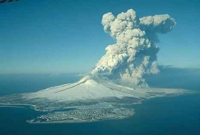
A volcano can be simply defined as an opening on the Earth crust. This opening allows hot ash, molten rock and gases to blow off from the underground spaces. Volcanoes generally acquire shape of a mountain. Volcanoes are usually found at places where tectonic plates get converged or diverged. But there existence at a particular place depends upon many environmental and geological factors. Volcanoes can also occur at a place because of hot spots or mantle plumes. Even hotspot volcanoes are very common at other planets of solar system especially on moons and rock based planets.
Figure 16.5: An Image of a Typical Submarine Volcanic Eruption
Features of Volcanoes
Common features of volcanoes are lava, conical shaped mountain and release of poisonous gases from the carter situated at the summit of the volcanoes. These are most common features attained by almost all of the active volcanoes. Material erupted by a volcano is called as lava. Lava is just a name given to magma,
once it gets erupted from the mouth of volcano. But describing complete features of all the volcanoes is a very tedious thing, because shape, attributes and behavior of different volcanoes depends upon different factors.
Submarine volcanoes- These are the volcanoes which are located at the floors of oceans (Figure 16.5). They can be at lower or extreme depths. Those volcanoes which are present at lower depths produce bubbles of steam and gases, which can be observed above the sea surface. But other volcanoes which are present at extreme depths are almost invisible about their existence. But even these deep volcanoes can also be marked by observing discoloring of water at a particular portion of ocean. This discoloration is because of release of volcanic gases in the sea. Other less common types of volcanoes are sub glacial volcanoes, Antarctica volcanoes, mud volcanoes etc.
Volcanoes on basis of Activities
On basis of activities volcanoes are classified into three types: active, dormant and extinct. Those volcanoes which are showing eruption regularly are called active volcanoes. A volcano can be simply considered as active one if in current times it is showing eruptions or simply acting restless. Dormant- Those volcanoes which have previous record of eruption in historical times but which are quite from many years are considered as dormant volcanoes. Extinct- Those volcanoes about which no previous record of eruption is available and which are quite in current times also are considered as extinct volcanoes. In other words, these are simply those volcanoes about which it has been already postulated that they will not erupt again, because they have no current connections for supply of lava. So these rae simply non-erupting dead volcanoes.
Effects of Volcanic Eruptions
Different volcanic eruptions produce different sort of effects on environment and society. General eruption contains gases like water vapors, SO2, HF, CO2, HCl and ashes of melted rocks. Explosive eruptions supply these materials directly to the stratosphere at the heights of 16–32 kms. Now in stratosphere SO2 gets converted into H2SO4, this H2SO4 gets condensed into the sulfate aerosols. Accumulation of sulfate aerosols in earth’s atmosphere increases its reflection for the rays of sun; as a result temperature gets decreased in lower layer of atmosphere called troposphere, but due to accumulation of aerosols in stratosphere, temperature gets increased here. This temperature cuts and fluctuations produce large effects on overall earth’s temperature. Accumulation of sulfate aerosols also causes chemical reactions which eventually cause destruction of protective ozone layer of earth’s atmosphere. Acid rain is also a common effect of volcanic eruptions. Moreover when a volcanic eruptions occurs the flow of lava destroy all the surrounding crops of the region and people need to migrate from that zone because flow of lava destroy each and each every thing coming on its way. Ash and rain of molten rocks are other effects of volcanic eruptions.
Disaster Management
Disaster management is an applied science- a special type of emergency management- which seeks to improve measures relating to prevention, mitigation, preparedness, emergency response and recovery by the systematic observation and analysis of disaster. In Bangladesh, disaster management includes the following cycles:
Disaster Preparedness is the most important phase of the whole process of Disaster Management. It includes forecasting and taking precautionary measures prior to an eminent threat. It also includes the formulation of a viable counter disaster plan, maintenance of inventories of resources and the training of the personnel. Disaster preparedness minimizes minimizes the loss of an extreme event through effective readiness measures to expedite emergency action, rehabilitation and recovery, ensuring the timely, appropriate and efficient delivery of relief and emergency assistance following a disaster.
Disaster Response may be defined as the sum total of actions taken by the mass and the institutions in the face of a disaster. It includes the implementation of Disaster Preparedness Plans and Procedures, and also the completion of disaster rehabilitation program. The activities of disaster response cycle could be
exhaustive, but essentially involves warning, evacuation, search and rescue, post disaster assessment, emergency relief, logistic and supply, information and communication, survivor response and coping, security, rehabilitation and reconstruction.
Disaster Mitigation means risk reduction which can be classified in a number of ways: active and passive; structural and non-structural; restrictive and incentive; Spatial and sector based. It encompasses all actions taken prior to the occurrences of a disaster including long-term reduction and preparedness measures. Mitigation tries to lessen the impact of disaster by improving the community’s ability to absorb the shock of with minimum damage, loss disruptive effect. Mitigation applies to measures such as structural engineering projects, spatial planning, economic planning, institutional management, conflict minimization and societal action.
Organizational Arrangement of Key Bodies in Bangladesh
The most difficult of part of disaster management is the availability of correct data for disaster planning and mitigation. Loss and damage reports are often exaggerated that these data make disaster related planning complex. Despite the fact, Bangladesh has well-developed institutional framework and sub-systems for managing the consequences of natural disasters. Under the Government orders, the following council and committees at the national level are concerned with disaster management:
National Disaster Management Council (NDMC): Responsible for establishing policies and providing overall direction for all aspects of disaster management; also define priorities and criteria for the allocation of resources.
Inter Ministerial Disaster Management Co-ordination Committee (IMDMCC)
Implement NDMC policies and provide direction on an inter-ministerial basis. Coordinate actions taken by all governmental bodies and direct activities of the DMB. Responsible for major operational decisions during an emergency; make decisions on allocation of relief materials.
National Disaster management Advisory Committee (NDMAC)
Provide advice to the NDMC and directly to the MDMR and DMB on technical and socio-economic aspects of disaster management.
Ministry of Disaster Management and Relief (MDMR)
Responsible for disaster management at the ministerial level including the convening of the NDMC and IMDNCC; ensuring the efficient functioning of DMB (resource, budget etc.)
Disaster Management Bureau (DMB)
DMB) is a concise dynamic professional unit at national level working in close collaboration with the District and Thana level authorities and the concerned line ministries (under the overall authority of IMDMCC) to perform specialists functions. DMB is a part of MDMR which ensures provision of expert staff services to the NDMC and IMDMCC. It promotes disaster preparedness including prevention and mitigation at all levels of government and agencies. It also provides guidelines, organize training, and promote the preparation of disaster plans.
Directorate General of Relief and Rehabilitation (DRR)
Responsible for management and delivery of relief supplies including the provision of related services.
NGO Involvement in Disaster Management
Besides government, some NGOs are also involved in disaster management activities (rescue, relief, rehabilitation, disaster related training and public awareness building) in Bangladesh (in keeping close contact with local committees at different levels.