Course description
Introduction
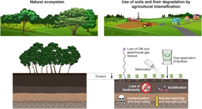
Agro-ecosystems are biological and natural resource systems managed by humans for the primary purpose of producing food as well as other socially valuable nonfood goods and environmental services. These are contained within larger landscapes, which include uncultivated land, drainage networks, rural communities, and wildlife. Agro-ecosystems cover more than one-quarter of the global land area, but almost three-quarters of the land has poor soil fertility, and about one-half has steep terrain, constraining production. A further limitation is the growing competition from other forms of land use such as urban, industrial, commercial, or residential. While the global expansion of agricultural area has been modest in recent decades due to various reasons, intensification has been rapid; as irrigated area increased, fallow time has decreased and the use of new inputs with modern technologies has grown and is producing more output per ha than ever. At a time when the world's human population is expanding rapidly and its need for more land to produce food, fiber and fuelwood is also escalating, valuable land is being degraded through erosion and other means at an alarming rate. According to the Pilot Analysis of Global Ecosystems (PAGE) study, about two-thirds of agricultural land has been degraded in the past 50 years by soil erosion, salinization, compaction, nutrient depletion and pollution. Globally, about 40 percent of agricultural land has been strongly degraded, and about 65 percent of agricultural land has experienced some amount of soil degradation. This chapter presents the goods and services produced by world agro-ecosystems including human nutrition, and describes its extent, growth, alteration, present state, constraints, and the challenges (e.g. soil erosion, degradation etc.). This chapter also examines agricultural situation in Bangladesh with a focus on land degradation, desertification in the Northern region, technological issues and the environment. The chapter then briefly discusses the issues of land use changes (conversion) including management options. It may be pointed out that there are several issues related to land degradation that intersect with other concerns. The most important of these have been addressed in other chapters of this book. For example soil pollution is addressed in Chapter 11, and floods and droughts are discussed in Chapter 16 under natural disasters. The biodiversity chapter addresses issues of shrinking wetland in the dry season.
A: Agro-ecosystems
Economic Importance
Goods and Services: Agricultural ecosystems or “Agro-ecosystems” cover 28 percent of the world’s land surface (excluding Antarctica and Greenland). In 1997, global agriculture accounted for US$1.3 trillion in output of food, feed and fiber, and for 99 percent of the calories human consumed. Of the economic activities, agriculture is most important to developing countries, accounting for 31 percent of their GDP, and more than 50 percent in many parts of Sub-Saharan Africa. In middle-income countries, agriculture account for 12 percent of GDP. But in the industrialized countries of Western Europe and North America, the contribution of agriculture to GDP is less than 3 percent, although the value of the agricultural output in these countries represents 79 percent of the total market value of world agricultural products. Beyond the economic value of the agricultural products, agro-ecosystems provide employment for millions. In 1996, out of 3.1 billion people living in rural areas, 2.5 billion- 44 percent of the world population-were estimated to be living in households dependent on agriculture. The labour force directly engaged in agriculture is estimated to be 1.3 billion- about 46 percent of the world’s labour force. From a regional perspective, East, South and South East Asia as well as in Sub-Saharan Africa, agricultural labour accounts for 56-65 percent of the total labour force, as oppose to only 2.4 percent in North America.
Human Nutrition: Globally, agro-ecosystems have been very successful in keeping pace with the demand for food, feed and fiber in response to population growth. Since 1970, crop outputs have doubled and livestock products have tripled. On average, per capita food supplies were 24 percent higher in 1997 than in 1961, and real food prices were 40 percent lower. In fact, global agro-ecosystems produce sufficient food to provide every person on the planet with 2,757 kcal a day, which is enough to maintain a productive and healthy life (minimum human requirement for nutrition). However, the irony is, many people do not have adequate access to the food they need, and an estimated 790 million people (1999) are ill fed or chronically undernourished in the midst of ample food supply. The highest incidence of undernourished people is in Sub-Saharan Africa (33 percent) followed by the Caribbean (31 percent), and South Asia (23 percent). Further, global demand for food has been increasing since 1980, driven by population growth, urbanization and income induced changes in lifestyles. One of the most remarkable changes in such demand is the dramatic increase in meat consumption, particularly in the developing world- commonly labelled by as “Livestock Revolution”. Between 1982 and 1994, global meet consumption grew by 2.9 percent on an annual basis, but it grew five times faster in developing countries than in developed countries, where meat consumption is already saturated. Between 1995 and 2020, global population is expected grow by one-third, totalling 7.5 billion people. Global demand for cereals is projected to rise by 40 percent with 85 percent of the increase in demand coming from developing countries. Meet demand is projected to increase by 58 percent with roughly 85 of the increase coming from developing countries- an indication of additional feed requirement. Demand for roots and tuber crops is expected to grow 37 percent, with 97 percent of this increase is coming from the developing world. If income level of the poor goes up or significant progress is made in poverty alleviation during this period, there will be a further increase in demand for food. This is simply because the poor and malnourished are more likely to use their increased income to buy food from the ample supply (market) as they previously could not afford to do so.
State of the Agro-ecosystems
An agro-ecosystem may be defined as a dynamic association of crops, pastures, livestock, other flora and fauna, soils, water, and the atmosphere. It is the basic unit of study for an agro-ecologist, and is somewhat arbitrarily defined as a spatially and functionally coherent unit of agricultural activity, and includes the living and nonliving components involved in that unit as well as their interactions. It can be viewed as a subset of a conventional ecosystem. At the core of an agro-ecosystem, lies the human activity of well managed agriculture (Figure 5.1). However, an agro-ecosystem is not restricted to the immediate site of agricultural activity (e.g. the farm), but rather includes the region that is impacted by this activity, usually by changes to the complexity of species assemblages and energy flows, as well as to the net nutrient balance.
Figure 5.1: A Typical Agricultural Field; Source: Google image
Extent and Growth: Agriculture is one of the most common and major land uses on the planet Earth. Naturally, agro-ecosystems in the world are quite extensive and determining their extent is not an easy task; it depends on how they are defined and utilized. The Pilot Analysis of Global Ecosystems (PAGE) study, mostly making use of satellite imagery, defined agricultural areas as those where at least 30 percent of the land is used for cropland or highly managed pasture. With respect to this definition, agro-ecosystems cover approximately 28 percent of total land area (excluding Greenland and Antarctica). Since this measure allows some overlaps with forest and grassland ecosystems, the Food and Agricultural Organization of the United Nations (FAO), reports (2000) an even greater percentage (37) of land under agriculture. The difference between PAGE and FAO figures lies in the fact that FAO’s figures are derived from national production statistics rather than from remote sensing data, and include all permanent pasture. The actual area of agro-ecosystems probably falls some where between these two estimates. According to FAO estimates, the total area under global agriculture expanded slowly between 1966 and 1996, from 4.55 Bha to 4.92 Bha- about an 8 percent increase. Despite this growth, agricultural area has actually decreased in many industrialized countries. The United States, Western Europe, and Oceania (mainly Australia) have progressively been taking land out of agriculture for the last 30 years (Figure 5.2). These regions have removed a total of 49 Mha from agricultural production. Agricultural land has also decreased in Eastern Europe, mainly because of liberalization of trade policies and poor economic conditions. South Asia’s total agricultural area has remained stable for more than 20 years at roughly 223 Mha. However, slow expansion of agricultural area is still observed in some regions such as in China and Brazil (by 0.8 percent per year) between 1986 and1996.
Figure 5.2: Area of Agro-ecosystem; Source: World Resources Institute 2000
Physical Constraints: Many of the world’s agricultural land, offers less than optimal conditions for normal agricultural practices. Poor soil conditions limit production on a significant portion of global agricultural land. Constraints of soil fertility include high acidity, low potassium reserves, high sodium concentrations, low moisture-holding capacity, limited depth or steep slopes. Approximately, 36 percent of world agricultural land is characterized by significant soil constraints including slopes of 8 percent or more (inclination). On a regional distribution, areas with both steep slopes and significant soil constraints make up 30 percent of temperate, 45 percent of subtropical and, 39 percent of tropical agricultural land. In these regions, average agricultural yields are generally lower and degradation risks are generally higher than in more ecologically favoured environments. Anyway, these marginal lands represent a significant share of global agriculture and support approximately one-third of the world’s population.
The Challenges
Intensification of agriculture: As population has grown and good agricultural land has become scarcer, inputs such as water for irrigation, modern seed (HYV), chemical fertilizer, pesticide, herbicide and labour have been applied more intensively to increase crop output. Although the net global expansion of agricultural area has been modest in the past three decades, intensification of agriculture has been quite rapid. Irrigated area, for instance, grew from153 Mha in 1966 to 271 Mha in 1998- a significant expansion. Although global irrigated land accounts for only 5.5 percent of total agricultural land- 17.5 percent of cropland- in some regions irrigation is much more extensive. For example, where Sub-Saharan Africa and Oceania (mainly Australia) together represent only 3 percent of the global irrigated land, China and India contain 41 percent of the world’s irrigated area. In the later group (Asian countries), where population pressures are greatest, virtually all of the cropland is harvested each year, some times two to three times a year, as the use of new technology has replaced traditional practices of leaving land fallow to restore fertility. Even marginal lands in Africa are in continuous use to meet demands for food. Many agro-ecosystems are vulnerable to the stresses imposed on them by intensification of agriculture. There is much local evidence of soil salinization and waterlooging due to poorly managed irrigation (see Chapter 11); loss in soil fertility caused by over-cultivation and compaction by tractors or livestock, and lowering of water tables through over pumping for irrigation.
Extent of Soil Degradation: The condition of soil is a good measure of the long-term productive capacity of an agro-ecosystem. We generally consider the land degraded when the soil is impoverished or eroded, water runs off or is contaminated more than is normal, vegetation is diminished, biomass production is decreased, or biodiversity diminishes. Degradation of the land resource means to a great extent a degraded agro-ecosystem on which depends the livelihood of the rural mass. Today, agriculture provides the majority of crops, feed and livestock on which human nutrition depends. On farmlands the degradation results in low crop yields; on ranchlands it means fewer livestock can be supported per unit area; on nature reserves it means fewer species. Land degradation is of great concern because soil reformation is extremely a slow process. Although, topsoil is classified as a potentially renewable resource (as because it is continuously regenerated by natural processes), in tropical and temperate regions of the world, however, it takes roughly 200-1,000 years (depending on climate and soil type) for 1 inch (2.54 centimeters) of new topsoil to form.
Figure 5.3: An Image of Typical Soil Degradation
Figure 5.4: An Image of Typical Land Degradation
The International Soil Reference and Information Centre in the Netherlands estimates that every year roughly 3 million ha (7.4 million ac) of cropland are ruined by soil erosion, 4 million ha are turned into deserts, and 8 million ha are converted to nonagricultural uses such as homes, highways, shopping centres, factories, water reservoirs etc. Worldwide, some 1.9 billion ha of agricultural land have been degraded to some extent; about 300 million ha of this land is strongly degraded, while 910 million ha- about the size of China- are moderately degraded. Nearly 9 million ha of former croplands are degraded to such an extent that they no longer support any crop growth at all. The 1990 Global Assessment of Soil Degradation (GLASOD) provides a more comprehensive global scale estimates of soil degradation. The GLASOD study suggested that between the mid 1940s and 1990 some 1.97 Bha of land had been degraded representing 15 percent of terrestrial area (excluding Greenland and Antarctica). Although different types of soil degradation are associated with different kinds of agricultural land use, in cumulative terms, about two-thirds of agricultural land has been degraded in the past 50 years by erosion, salinization, waterlogging, compaction, nutrient depletion, and pollution (Figure 5.5) . About 40 percent of global agricultural land has been strongly degraded. South and Southeast Asia, for example, where agricultural production systems are among the most intensive in the world, have soils that are among the most degraded. In these regions, soil slopes are significantly steeper, more subject to erosion, and more likely to be salinized, acidic, depleted of potassium, and saturated with aluminium than the soils of most other regions.
The cumulative productivity loss from soil degradation over the past 50 years (as has been roughly estimated by PAGE researchers, using GLASOD figures), are to be about 13 percent for cropland and 4 percent for pasturelands. The economic and social impact of soil degradation has been even far greater in developing countries than in industrialized countries, particularly on the issue of food supply. Agricultural productivity is estimated to have declined significantly on approximately 16 percent on agricultural land, especially on cropland in Africa and Central America. Sub-regional studies have documented significant aggregate declines in crop yields due to soil degradation in many parts of Africa, China, South Asia, and Central America. Crop yield losses in Africa from 1970 to 1990 due to water erosion alone are estimated to be 8 percent. Total annual economic loss from soil degradation in South and Southeast Asia is estimated to be 7 percent of the region’s agricultural GDP. Agriculture faces an enormous challenge to meet the food need of growing population. If proper preventive measures are not taken, the situation will worsen and national food security will be seriously hampered.
Figure 5.5: Areas of Concern for Soil degradation; Source Google image
Extent of Topsoil Erosion: The movement of surface litter and topsoil from one place to another is called topsoil erosion. Due to overgrazing by cattle or other human activities, the cover of vegetation almost gets removed from the land; the soil becomes exposed and gets eroded by the action of strong wind, rainfall etc. Since the grassroots are very good binders of soil, when removed the soil becomes loose and susceptible to the action of wind and water. The rates of erosion vary from region to region because of topography, rainfall, wind speed, and the type of agricultural practices used. In China for example, the average annual soil loss reported to be about 40 metric tons per ha (18 tons per acre), whereas the U.S. average is 18 metric tons per ha (16 tons per acre). The two main natural agents of erosion are flowing water and wind. However, some anthropogenic activities such as farming, logging construction, overgrazing by livestock, deliberate burning of vegetation and other actions that destroy plant cover leave soil vulnerable to erosion (Figure 5.6). Today, topsoil is eroding lot faster than it forms, causing an estimated 85 percent of the world's land degradation. A study (1992) by the World Resources Institute and the UN Environment Programme found that soil on more than 12 million square KM of land- an area the size of China and India combined- had been seriously eroded since 1945. The study also found that about 89,000 square KM (34,000 square miles) of land scattered across the globe was eroded to such an extent that crop growth is no longer feasible because of a combination of overgrazing (35 percent), deforestation (28 percent), and unsustainable farming (28 percent). Two-thirds of the seriously degraded lands are held in Asia and Africa. Each decade, the world is losing about 7 percent of its topsoil from actual or potential cropland. The situation is worsening as many farmers in LDCs plow up marginal lands to survive. If topsoil erodes faster than it forms on a piece of land, the soil there becomes a non-renewable resource. According to an estimate, annual erosion rates for farmlands throughout the world are 7-100 times the natural renewal rate. Cropland aside, construction sites usually have the highest erosion rates by far.
Nutrient Depletion: Besides reduced soil depth, soil erosion leads to reduce crop productivity because of loss of water, organic matter and soil nutrients. When soil erodes, vital plant nutrients such as nitrogen, phosphorous, potassium, and calcium are also lost. Losing topsoil makes soil less fertile; less able to hold water and as such low productivity. Chemical fertilizers do not have humas content that reduces the soil’s ability to hold water, and as a result of their application the soil is more likely to become compacted- less suitable for crop growth. Further, the resulting sediment clogs irrigation ditches, boat channels, reservoirs, and lakes. The sediment-laden water is cloudy, and tastes bad, fish die, and flood risk increases. Soil erosion is one of the world’s critical problems; if not slowed, it will seriously reduce agricultural production and degrade the quality of agro-ecosystem. With U.S. annual cropland erosion rates of about 18 metric tons per ha, an estimated $18 billion of plant nutrients are lost annually.
Figure 5.6: Soil Erosion; Source: Google image
Changes in Yield Growth: Soil erosion can lead to poor crop growth and yield reductions through loss of soil fertility and plant nutrient depletion. Moreover, soil structure, texture and stability can be affected by such losses. Global agriculture today faces an enormous challenge to meet the food need of an additional 1.7 billion people- the projected population increase by 2020. Rapid yield growth in major food crops (mostly cereals) has been instrumental in meeting the food need of growing populations, particularly in the second half o the past Century. Recently, however, the growth of yield in cereal crops has been slowing, raising concerns that future production may not be able to keep pace with demand. Moreover, there are local evidences that maintaining the growth yields, or even holding yields at current levels, requires proportionately greater amounts of fertilizer input, implying that the quality of the underlying soil resource may be deteriorating (see Chapter 11- Land Degradation for detail).
Management: Soil Conservation Practices
The art of soil conservation is concerned with keeping the soil intact and maintaining the soil nutrients at a certain desired level following certain basic principles. Soil conservation involves reducing soil erosion and preventing and storing soil fertility. With careful husbandry, soil can be replenished and renewed indefinitely. Among the most important considerations in a soil conservation program are topography, ground cover, climate, soil types and tillage systems. Water runs downhill. The faster it runs, the more soil it carries off the lands. Water runoff can be reduced by leaving grass stripes in waterways and by strip- farming- the planting of different kinds of crops in alternating stripes along the land contours. The stripes of cover crop trap soil that erodes from the row crop, and catch and reduce water runoff. Terracing can be used to reduce soil erosion on steep slopes, each of which is converted into a series of broad, nearly level terraces that run across the land contour (Figure 5.7). The edges of the terrace are planted with soil anchoring plant species. Terracing retains water for crops at each level and reduces soil erosion by controlling runoff. In mountainous areas such as Himalaya, and the Andes, farmers have traditionally built elaborate systems of terraces. Soil erosion can be reduced by 30- 50 percent on gently sloping land by means of contour farming- plowing and planting crops in rows across, rather than up and down, the sloped contour of the land. Each row planted along the contour of the land acts as a small dam to help hold soil and slow the runoff of water.
Soil erosion can also be reduced by alley cropping or agro-forestry- it is a form of intercropping in which several crops are planted together in stripes or alleys between trees and shrubs that can provide fruit or fuel wood. The trees provide shade and help to retain and slowly release soil moisture. Sloping bare land on which water runoff quickly creates gullies can be restored by gully reclamation. Small gullies can be seeded with quick-growing plants such as wheat, oats, and barley for the first season, whereas deeper gullies can be dammed to collect silt and gradually fill in the channels. Fast-growing shrubs, vines and trees can also be planted to stabilize the soil. Regarding ground cover, the easiest way to provide cover that protects soil from erosion is to leave crop residues on the land after harvest. Mulch is a general term for protective ground cover that can include manure, wood chips, straw, seaweed, leaves, and other natural products. In conventional-tillage farming, the land is plowed and then the soil is broken up and smoothed to make a planting surface, thus leaving it vulnerable to erosion. However, as oppose to this method, many U.S. farmers are trying conservation-tillage farming. The idea is not to disturb the soil while planting crops. With minimum tillage farming, special tillers break up and loosen the subsurface soil without turning over the topsoil, previous residues and cover vegetation. In no-till farming, special planting machines inject seeds, fertilizers, and weed killers into slits made in the unplowed soils. Conservation tillage is used on about one-third of U.S. croplands. The U.S. Department of Agriculture (USDA) estimates that using conservation tillage on 80 percent of U.S. cropland would reduce soil erosion by at least half.
Figure 5.7: Strip Farming in Bali, Indonesia; Source: Google Image
Implications for Bangladesh
Importance of Agricultural Sector
Bangladesh is predominantly a rural-agrarian country. The great uniformity of landmass, the fertile alluvial soil, and the tropical monsoon climate provide excellent conditions for agricultural production. Land is the most precious of all natural resources in Bangladesh. Degradation of the land resource means to a great extent, a degraded agro-ecosystem on which depends the livelihood of the rural mass (Figure 5.8). The role of agriculture in the growth and stability of the economy of Bangladesh can hardly be estimated. Agriculture accounts for nearly one-fourth of GDP (contribution includes its sub-sectors of crops, livestock, forestry and fisheries), and about two-thirds of employment. Although the share of agriculture to GDP has been declining since her Independence in 1971, it will remain the largest single contributor to the economy in the years to come. This sector will not only play a vital role in achieving self-sufficiency in food production, but will also continue to be an important source of export earning, particularly in the areas of diversification. The crop sub-sector, which was 79 percent of the total agricultural output in 1990/91, dominates the agricultural scenario in Bangladesh. Food crops alone account for about three-quarters of the total agricultural output. Rice is the principal food crop that covers about 75 percent of the total cropped area, accounts for 70 percent of the value (added) of total crop output, and constitutes 92 percent of the total foodgrains produced annually in the country. Being the staple food of Bangladeshi people, rice provides about 75 percent of the calories and 55 percent of the protein in the average daily diet, and ensures political stability for the country. Since the stable supply of rice has great implications for food security, many views food security as synonymous to achieve self-sufficiency in rice production. The dominance of rice in the crop sub-sector virtually assures stability in the structure of production. Major shifts in crop diversification will be limited as long as rice is important to the diet of the nation as the chief source of calorie and protein. Wheat, potato, pulses, and oil seeds are the other principal food crops. If proper preventive measures are not taken, the situation will worsen and food security will be seriously hampered. This section deals with causes of land degradation in Bangladesh both in terms of deterioration of soil quality and loss of land.
Figure 5.8: A Typical Agro-ecosystem in Bangladesh
Agricultural Intensification and Performance
Population growth and scarcity of cultivable land in Bangladesh have led to more intensive agriculture and cultivation of HYV of crops to meet the growing need for more food. In fact, Bangladesh has made steady progress in food production in the post-Independence period. Advances in rice science and technology have enabled Bangladesh to meet the food needs of fast growing population. Rice production increased substantially over the years following the introduction of HYV seeds, and application of modern agricultural inputs i.e. use of chemical fertilizers along with pesticides, and irrigation. The total land irrigated in the country in 1999-2000 was 4.51 million ha, which has increased to 5.26 million ha in 2005-06 or 66 percent of the net sown area. The use of chemical fertilizers and pesticides in crop cultivation in Bangladesh has also increased tremendously. On the average, about 160,000 tons of chemical fertilizers and 3000 tons of pesticides were used in 1990. Since 1980s, the use of chemical fertilizer in Bangladesh has been consistently increasing. The total quantity of chemical fertilizer used in 2005/2006 was about 3.7 million mt, a four-fold increase over its use in 1980/81. In recent years, use of pesticides has also increased at an alarming rate; in 1997 it was 11,367 mt and by 1999 it had increased to 14,340 mt. In terms of output, between 1971/72 and 2004/05 rice production has more than doubled- increased from 9.8 million mt to 25.2 million mt. This impressive growth in rice production over the last three decades or so has generated a sense of complacency regarding Bangladesh's ability to meet the future demand for rice.
Impacts of Technology on the Environment
Acceleration in production has resulted in an increase in per capita rice availability, and led to self-sufficiency in output by the early 1990s. Intensive rice cultivation, however, has been under some strains since then. There are many studies reporting that recent trend in the growth in rice production raises serious concern regarding the sustainability of the past achievements. Despite increases in input application, yields per acre have declined or stayed the same on about two-thirds of the area planted with HYVs in the 1990s. Changes in rice productivity under modern inputs although reveal some interesting points regarding self-sufficiency it has failed to achieve the goal of sustainable production in real terms. Maintaining the growth in yield or even holding yields at current levels requires greater amounts of fertilizer input, implying that the quality of the underlying soil resource base may be deteriorating. According an estimate, about 1.8 million ha of land in Bangladesh are either on the threshold level or acute stage of zinc deficiency. Out of 27 agro-ecological zones in Bangladesh, 18 fall in the nutrient grades of poor to very poor in 1998.
Fertilizer and pesticides over-dozes have already been depleting soil fertility in Bangladesh. Chemical fertilizers do not have humas to the soil, and thus its ability to hold water will decrease, and the soil will soon become compacted and less suitable for crop growth. By decreasing the soil’s porosity, inorganic fertilizers also lower the oxygen content of soil. Although pesticides are used at low dozes still they are a cause of soil contamination (sprayed over standing crops ultimately contaminate the surrounding soil). The pesticides not only destroy harmful insects, but also destroy beneficial top soil microbes- resulted in reduction of the biological nutrient replenishment of the soil and reducing its fertility. Although irrigated land can produce crop yields that are two to three times greater than those from rain-fed systems, irrigation has downside. As a result of irrigation, the land remains inundated in most of the seasons, which creates an adverse effects on soils because of continued oxygen deprivation in the sub-soils. Further, irrigation may destroy soil fertility through salinization (Chapter 6), the accumulation of which stunts crop growth, lower yields, and eventually kills crop plants, and ruins the land. According to an estimate severe salinization to date has reduced yields on 10 percent of the world’s irrigated cropland, and another 30 percent has been moderately salinized. Further, continuous waterlogging (Chapter 6) will mean absence of oxygen in the soil. Prolonged submersion in water will leach out micronutrients and organic matters in the soil, resulting in the loss of soil fertility. Waterlogged soil environment is the breeding ground for different types of pests and disease causing microbes and animals.
Overall, the impression of intensive rice cultivation is that the resource base for agriculture is shrinking. If the present cultivation systems continue, then by 2020 land degradation may pose a serious threat to food production. Bangladesh will face enormous challenge by 2020 in trying to achieve food self-reliance and to ensure food security for all in the country. Demand for rice will increase with the increase in population. According to an estimate, the population of Bangladesh will be 169 million by the year 2025. As a result, land-person ratio will decline gradually. To feed the extra million, Bangladesh will be in need to produce about 27.8 million mt of clean rice by the year 2025, which is roughly 21 percent higher than the production level of 2000. The demand has to be met from our limited and shrinking land and water resource bases. Therefore, a core concern of all of us is how to sustain rice productivity while protecting and enhancing the environment.
Management
Continued agricultural intensification need not lead to excessive environmental degradation. Farming communities in all parts of the world have responded to soil degradation, particularly when it affect their livelihoods, with measures such as planting trees to control erosion, regulating cultivation around local water sources, utilizing organic fertilizers, salt tolerant species of vegetation, drought resistant crop varieties, restricting over extraction of groundwater, pesticides, controlling pests by using different biological and physical methods (integrated pest management such as frog farming in crop land is ecologically sound- kills insects) and other pollutants, designing good drainage networks, rehabilitating degraded soils, and adopting new technologies for efficient use of irrigation waters. The development of biotechnology suitable for land scarce conditions is a very important consideration in this regard. Development of ecologically sound technologies such as integrated pest management, and restoration of soil fertility through better management of soil organic matter (bio-fertilizers) is recommended. The introduction of legumes and green manure into the cropping pattern and minimum tillage in combination with crop residues can contribute to higher level of production and also improve soil fertility. Farmers should be encouraged to adopt farming practices that are ecologically sound for their areas including organic farming. Indigenous farming systems often contain a wealth of environmental knowledge, which needs to be assessed and adapted with the changing circumstances. More funds have to be allotted to smallholder needs and more incentives given to scientists.
B: Land Resources
Land is a finite and valuable natural resource. We depend on land for our food, fibre, fuel wood and the other basic amenities of life. Soil, specially the top soil, is classified as a potentially renewable resource because it is being continuously regenerated by natural process, although at a slow rate. However, when rate of erosion is faster than rate of renewal, then the soil becomes a non-renewable resource. Experts believe that the average global soil erosion rate per annum is 20-100 times faster than the renewal rate. Moreover, with rapid population growth, the demand for land is also increasing. Hence, there is more and more pressure on the limited land resource base, which is getting degraded due to overuses. Land degradation is a real problem because soil formation is an extremely slow process. According to an estimate, about 200-1000 years are needed for the formation of one inch (2.5 cm) soil, depending on the soil type and climatic factors.
Land Degradation
Land degradation is a process which leads to decline in the fertility or future productive capacity of soil as a result of human activity. In other words, it is commonly referred to the unfavourable alteration of our land resources largely because of anthropogenic activities. That means loss in the capacity of a given land to support growth of useful plants on a sustained basis. Land degradation is one of major ecological issues of the world which may be defined as an overall lowering of land qualities because of adverse physical and chemical changes brought in by human activities in to such an extent that these changes adversely affect all biological communities in general and human society in particular. Top soil erosion, nutrient depletion, loss of organic matter, accumulation of pollutants in the soil due to industrial effluents, uses of agro-chemicals such as fertilizers and pesticides, acid deposition, irrigation related problems such as slinization and waterlogging of soils, and lowering of water tables are some of the pressing land degradation issues of our time. These are results of many factors and/ or combination activities which damage the soil and restrict their use or production capacity. Considering its impacts on food security and environment, it is being important in many parts of the world. The productivity of some lands has declined by 50 percent due to soil degradation and desertification. Large-scale degradation of land resources has been reported from many parts of the world. From Table 6.1 it appears that about 70 percent of the total land of the world is under degradation.. The economic impact of land degradation is extremely severe in densely populated regions of South Asia and Sub-Sahran Africa. In the case of Bangladesh, there is no exception. The main causes of land degradation in Bangladesh are rapid population growth accompanied by poverty, improper land use, lack of policy, ineffective implementation of existing laws and guidelines. Unsustainable agricultural practices, soil erosion, soil nutrient mining, loss of organic matter, soil compaction, contamination, land transformation such as encroachment of agriculture and settlements on forest lands also create pressure on limited land base. Further, growing demands for urbanization and rural infrastructure are also aggravating the situation; construction of roads, embankments, polders, earth excavation, mining and quarrying all lead to land degradation.
Table 6.1: World’s Degraded Lands by Regions (in million km sq.).
Continent Total Area Degraded Area % Degraded
Africa 14.326 10.548 73
Asia 18.814 13.417 71
Australia & the Pacific 7.012 3.759 54
Europe 1.456 0.943 65
North America 5.782 4.286 74
South America 4.207 3.058 73
Total 51.597 35.922 70
Source: Dregne and Chou, 1994.
Soil pollution is a form of land degradation. When the action of external factors leads to a deterioration of the soil quality by the removal of its useful chemical components- nutrients or by accumulation of toxic substances that are harmful to the flora and fauna using it, then it may be said that the soil is polluted. It is mainly the consequences of urbanization and industrialization, but modern day agricultural practices are also responsible for it. Soil is polluted when large quantities of wastes from different sources (urban industrial- chemical and metallic, municipal solid, radioactive etc.) are dumped on it or mix with the soil. In a natural state, soil inhibit distinctive flora and fauna such as bacteria, fungi, algae, protozoa, earth worms, several other pests and insects which make the biological system of soil complex. As such, soil has been a potential carrier of microbial growth and pathogens that endanger human health. While some microorganisms help in maintaining the soil fertility, others act as chronic pollutants.
Since the economy of Bangladesh is agro-based and land is a scarce resource in the country, is being degraded in different ways including pollution. But comprehensive studies are lacking on the issues of land degradation in Bangladesh. Table 5.1 presents the main factors that are causing land degradation in Bangladesh. Among the major types of land degradation that occurs in Bangladesh shifting cultivation, top soil erosion, nutrient depletion, salinization and waterlogging are important from the perspective of agro-ecosystems. However, the level of land degradation is not uniform in Bangladesh; its extent vary seasonally and by regions (i.e. The Chittagong Hill-Tracts, Modhupur forest, Barind Tract, coastal belt, and the flood plains) as well as the pressures are not always the same either.
Table 5.1: Factors Causing Land Degradation in Bangladesh
Soil degradation may be caused by a number of factors: (i) Physical- e.g. loss of top soil due to water or wind erosion; (ii) chemical- e.g. depletion of nutrients or toxicity due to acidity or alkalinity or water logging; and (iii) bio-chemical- which affects the micro-flora and reduce the microbial activity of soil. Some other factors such as deforestation, extensive cultivation of marginal land, improper agricultural practices like cropping intensity, soil compactness, monocropping, poor manuring, misuse of fertilizers, excessive irrigation, and mining may accelerate the process of land degradation. The following is the list of some driving forces of land degradation in Bangladesh and their impacts.
TABLE #
Driving Forces State and Impacts
Population growth Poverty; depletion of natural resources
Intensification of agriculture Soil erosion and nutrient loss; yield reduction; siltation
Bio-technology Misuse of chemical fertilizers and pesticides; soil pollution
Irrigation problems Salanization and waterlogging; soil degradation
Urbanization Increased land conversion and unplanned uses
Industrialization Open discharge of industrial chemicals to land; loss of quality
Rural settlement Conversion and seizing of productive agricultural land
Brick making and kiln Loss of topsoil; destruction of productive land
Quarrying and mining Degradation of land; Loss of soil quality
Construction of polders, embankments Loss of productive agricultural land
Construction of rural roads Loss of fertile agricultural land
Riverbank erosion Loss of land; degradation of quality
Land sub-divisions Fragmentation of holdings and degradation of quality
Shifting Cultivation
Improper cultivation in hill slopes, terraces and piedmont alluvial plains are major contributors to land degradation in Bangladesh. Shifting cultivation on hills, locally known as “Jhum” cultivation is a common practice (see Chapter 6 for details) among the tribal communities in the greater Chittagong Hill-Tracts CHT). This is the traditional community-based agricultural method practiced by indigenous people of CHT, is one of the major causes of land degradation- soil erosion. An evaluation of the Sanghu-Matamuhuri reserve forest indicated that shifting cultivation, which was practically non-existent in 1961, accounted for 17,135 ha in 1984. (about 23 percent of the total area). In recent years, this traditional agricultural practice is considered as the most inefficient way of using the virgin forest lands. The soils of hilly area are the most susceptible to water erosion in which sheet, rill and gully erosion occurs frequently. About 75 percent of the hilly areas in Bangladesh have very high susceptibility to erosion. Losing top soil make soil less fertile, less able to hold water. This often leads to low crop productivity because of loss of water, organic matter and soil nutrients such as nitrogen, phosphorous, potassium, and calcium.
Deforestation
Deposition of sandy materials on agricultural land is a consequence of deforestation in the hills of the upper catchment areas, particularly in the lower part of the piedmont areas of greater Mymensingh and valleys of Sylhet and the CHT. During the monsoon season, when heavy rainfall occurs in the upland areas, it causes flash floods in the low lands. The runoff carries sandy materials that spread over agricultural lands. Near foothills, such deposits are quite high that compels farmers to abandon the affected areas from agricultural production. According to a study, erosion of topsoil in CHT has increased, and 17 percent of the soil resources have deteriorated between 1964 and 1985. A study on top soil erosion in Khagrachari, Rangamati and Bandarban Districts reveals that top soil erosion ranges from 100 to 120 tons per ha annually. The resulting sediment clogs irrigation ditches, boat channels, reservoirs, and lakes. The sediment-laden water is cloudy, tastes bad, fish die and flood risk increases. Due to increase in the number population in the CHT region there is a high demand on agricultural production, which is also creating stresses on scarce forest lands. As a consequence, the normal regeneration time of forest is not being allowed, and the soil is loosing its fertility.
Human Settlements
The population pressure and scarcity of cultivable land has caused a heavy influx of settlers from the plain land to the unprotected forestlands of Madhupur and Barind tracts. The Madhupur forest area has almost been denuded due mainly to deforestation, and has further been aggravated by many other factors such as its closeness to the capital city- Dhaka, improvement to road communication, urbanization and industrialization. In the Barind tract, land degradation is caused mainly due to over exploitation of biomass from agricultural lands and unscientific agricultural practices- mostly cultivation of HYV rice through groundwater irrigation. The process has been aggravated not only by irregular rainfall, but also by reduced water flow in the adjacent rivers that normally play a vital role in replenishing soil fertility and researching aquifer. Clearing of forest land for settlements and unwise land management for agricultural use accelerate erosion of the top soil (Figure 5.9). As a result, the infertile compact clay is exposed to the surface.
Figure 9: An Image of Typical Land-Use Changes
Land Conversion
Construction of Road: Mileage of inter-District highways and network of rural roads have increased tremendously over the past few years. Most of these roads and highways traverse through the floodplain. These have to be constructed on raised ground as a protection against the annual flooding. Land is degraded in two ways: i) there is a huge loss of fertile agricultural land in a land hungry country. ii) Unplanned construction of rural roads may result in drainage congestion- ultimately causing flood. Urbanization: Urbanization is necessary for socio-economic development of a country, but the present process in Bangladesh invariable reduces the amount of good agricultural land. As urbanization proceeds, the requirement for space increases. Land development takes place in the urban fringe for the construction of residential, commercial and industrial buildings. Unplanned Industrial Development: As the urban area spreads outward, more and more fertile agricultural land is lost permanently. Unplanned industrial expansion is of great concern because it encroaches on fertile land, and industrial effluents deteriorate the quality of soils and affect fisheries. The rivers of Sitalakhya, Buriganga, Karnaphuli and Passur and their banks are a few of many good examples. Brickfields: Brickfields located on the outskirts of all the urban areas in Bangladesh are another source of land degradation. The brickfields are set up on marginal agricultural land; owners take lease of the land from farmers. Thus, each year the topsoil on thousands of acres of land is lost to brick making; the subsequent harvest is poor; regaining the strengths of the land is a time consuming process. Management: Proper land use planning and zoning would be appropriate measures to combat this type of land degradation.. Any necessary earth excavating activity should be balanced through replacement and preserving the topsoil.
Quarrying and Mining
In Bangladesh, quarrying for boulders, stones and gravel has become a threat to the environment. In Chokoria, Lama and Alikadam of Chittagong, boulders and stones and gravel are collected by cutting into hillsides and digging at their bases. The hills are laid bare as much of their natural rock formation is destroyed. Consequently, with the advent of the rainy season huge landslides and flash floods wash away villages in these areas. Large tracts of agricultural land are covered by sands and become unsuitable for cultivation. Mining for coal also degrades the land where this is practiced. The topsoil is removed and trenches are cut to reach the coal seams. The deeper layer of soil becomes devoid of nutrients that comes to the surface after the mining operation. Beside this, coal wastes left on the land makes it acidic so that nothing can grow on it. Management: Measures should be taken to stop rampant excavation of hills, and also earth excavation for the preservation of the topsoil.
Flood Protection Embankments and Polders
Bangladesh is a country of river networks. Embankments built along the riverbanks to protect the life and property of the people living on the floodplain may serve this purpose during moderate floods, but these have adverse environmental impacts on the land they are suppose to protect. Embankments intercept the natural flow of floodwater over the land and disrupt the natural delta building process. Flood brings sediment- a beneficial process whereby the fertility of vast tracts of land in the floodplain is renewed and ecological balance is maintained. This process is interrupted as embankments hamper accretion by stopping the sediment from spreading over the land. It also means a loss in soil fertility. Polders in the coastal areas: Agricultural lands in the coastal area are prone to incursion by saline water during the diurnal tide. Polders are built to protect such lands. Polders are built to protect such lands from saline intrusion of tidal water to increase agricultural productivity. However, there are problems. There was initial increase in crop production; later the polder areas have become waterlogged. Due to lack of proper maintenance, the connecting canals have silted up and the polder areas are at lower level than the channels. The brackish water entering the polder area during high tide cannot recede or cannot be drained out. Thousands of has of land have now become water logged and the soil salinity has increased, rendering these unsuitable for growing crops. Without immediate rehabilitation, vast areas of land will be permanently degraded. Beel Dakatia in the Khulna region had suffered a similar fate. Management: Construction of flood protection infrastructures such as embankments and polders should be undertaken in conjunction with the Environmental Impact Assessment (EIA). Since Bangladesh is pat of an active delta, the processes of delta formation should not be obstructed. Flood warning systems should be improved; homesteads should be built on raised grounds to protect human lives, property and livestock. Crops that are water tolerant or have a shorter growing season should be planted in flood prone areas.
Desertification
Desertification is a serious form of land degradation, a problem growing in many parts of the world. It is a process whereby fertile land is reduced to a desert-like condition, the transformation of which may take place in several stages. The barrenness of land is mostly human induced. It is the consequence of mismanaged use of land. Natural event like drought may only be partly responsible for this condition. In fact, drought may also be the outcome of the loss of vegetative cover. According to an estimate, moderate desertification may be linked to a 10-25 percent drop in crop productivity; severe desertification is 25-50 percent drop; and very severe desertification is a drop of more than 50 percent productivity. Every year, a significant portion of the land area of the earth is under the threat of desertification and 200,000 sq KM of its land is becoming a desert. The regions most adversely affected by desertification are areas located in arid and semi arid climates i.e. sub-Saharan Africa, the Middle East, Western Asia, parts of Central and South America, the western half of the United States, and Australia. In Bangladesh, the Northern region shows clear signs of desertification. The southwest region is also under a similar threat, although the factors responsible for it are somewhat different. According to an UN estimate, 8.1 million square KM (3.1 million square miles)- an area the size of Brazil and 12 times the size of Texas- have become desertified during the past 50 years. On a global scale, about 60 percent of rain-fed croplands, and 30 percent of irrigated croplands are threatened by desertification. The total area of this threatened land is 33 million square KM (13 million square miles)- about the size of North and South America combined. The cumulative effect of desertification threatens the livelihood of at least 900 million people in 100 countries. In the case of Bangladesh, the Northern region shows clear signs of desertification. The southwest region is also under a similar threat, although the factors responsible for it are somewhat different. If current trends continue, desertification could threaten the livelihoods of more than 1.2 billion people by 2010.
Figure 5.10: An Image of Land Degradation; Source: Google image
Figure 5.11: Desertification
Figure 5.12: Desertification
Figure 5.13: Land Degradation and Desertification
Figure 5.14: Land Degradation and Desertification
Causes and Consequences
In general, the barrenness of land is mostly human induced. It is the consequence of mismanaged use of land. Practices that make topsoil vulnerable to desertification include over cultivation, overgrazing on fragile rangelands; deforestation, mining, faulty irrigation techniques leading to increased soil erosion, fall of water table, soil compaction by farm machinery, salt buildup and waterlogging. Over cultivation of land results in exhaustion of nutrients presents in the topsoil. The depleted soil eventually becomes unsuitable for crop cultivation. Left fellow, it is soon eroded by wind and rain. For Bangladesh, the most important cause of desertification in its Northern and Southwestern region is withdrawal of water by India in upstream of the Rivers Ganges and Teesta. In Bangladesh, land that is intensively cultivated is showing a downward trend in productivity. To improve the yield of the cropped area, excessive chemical fertilizers are being used which, in turn, is destroying the natural fertility of the soil. Overgrazing on land, which has sparse vegetation, may lead to its total destruction. As the soil is striped bare, the topsoil is blown away by the wind or washed away by rain. Because of high population pressure and intensive agricultural practices, there is hardly any land for grazing animals in Bangladesh. Deforestation is a major problem faced by Bangladesh. Each year trees are cut down beyond the natural regeneration capacity of the forest ecosystem. Forests provide protective tree covers that keep the soil moist. The humus content of the soil being high, the water retention capacity is also high. When trees are felled indiscriminately, large areas of forestland become treeless. Exposed to the sun’s rays directly, the soil soon becomes dry as the rate of evaporation increases. It is than at the mercy of the wind and rain. The topsoil is soon lost and the land becomes barren. Drought: Natural event such as drought may only be partly responsible for this condition. In fact, drought may also be the outcome of the loss of vegetative cover. Every year, a significant portion of the land area of the earth goes under the threat of desertification. The consequences of desertification include worsening drought, famine, threat to biodiversity, declining living standards, and a growing numbers of environmental refugees. Frequent drought, however, is an indication of severe desertification.
Desertification in Bangladesh
As already mentioned above, the main causes of desertification are soil erosion resulting from over cultivation, overgrazing, deforestation, increase in soil salinity due to different reasons and fall in the underground water table. For Bangladesh, however, the most important cause of desertification in its Northern and Southwestern region is withdrawal of water by India in upstream of the Rivers Ganges and Teesta. Withdrawal of water in the upstream of the Ganges and other rivers flowing through India has led to drastic reduction in the availability of surface water in Bangladesh. The whole Northern region becomes dry. As there is no enough water to recharge the underground aquifers, the water table falls drastically. Further, the withdrawal of underground water for irrigation purposes, surpasses the rate of research of the underground aquifers. The fall in the water table makes it impossible for crops to grow in many areas. Water Withdrawal in the upstream of the Ganges and other rivers flowing through India has led to drastic reduction in the availability of surface water in Bangladesh. The whole Northern region becomes dry. As there is no enough water to recharge the underground aquifers, the water table falls drastically. Further, the withdrawal of underground water for irrigation purposes, surpasses the rate of research of the underground aquifers. The fall in the water table makes it impossible for crops to grow in many areas. These factors, accompanied by rapid population growth, povery and poor land management are aggravating the problem. The Ganges-Kobadak Project: In the southwest, dry season crop cultivation is dependent on irrigation. The Ganges-Kobadak Barrage project was supposed to provide adequate water of 400,000 acres of cropland. However, the project was adversely affected by the construction of the Farakka barrage in India. Due to shortage of water, large areas of land may undergo desertification if the project cannot be implemented and utilized fully. Drought: Although drought may seem to be a natural phenomenon, human activities leading to deforestation may reduce rainfall in an area and enhance drought like condition. Bangladesh often experiences moderate to severe droughts between October to May. Droughts are severe in the northwest and southwest regions of the country. These areas experience less rainfall during the year compared to other areas of the country and these are the areas undergoing desertification. Vast tract of land in the northwest known as Barind, are the worst affected areas. The summer months are hot and dry. Maximum temperature may soar to 43 degree C. Once green areas are denuded of trees, vegetation becomes sparse. To make matter worse, rivers are rapidly being filled up by sediments as the flow has decreased due to building of barrages in the upstream. Fields are flooded during the monsoon. However, as the flood recedes, crop fields are covered by coarse sands instead of the fertile alluvium that was previously deposited. Thus, many croplands are turning into vast tracts of sand-covered fields that cannot be productively cultivated. Further, in many countries of the world including Bangladesh, productivity of land is adversely affected by salinization. If irrigation of the crop is not managed properly it may lead to salinization of the soil (see Chapter 11).
Management
The most effective way to deal with desertification is to drastically reduce overgrazing, deforestation, and the destructive forms of planting, irrigation and mining that are to blame. More over, reforestation programs may be under taken which will anchor soil and hold water while slowing desertification and reduce the threat of global warming. Some beneficial effects of agro-forestry are as follows:
Reduction of loss of soil as well as nutrients through reduction of run-off;
Addition of carbon and its transformation through leaf, twig, bark fall etc.;
Nitrogen enrichment by fixation of nitrogen by appropriate trees, shrubs etc.;
Improvement of physical conditions of soil i.e. water holding capacity, permeability, drainage etc.;
Release and recycling of nutrients of by affecting biochemical nutrient cycling;
More microbial associations and addition of more root biomass;
Moderately affect on extreme conditions of soil acidity and alkalinity;
Create more favourable microclimate by windbreak and shelterbelt effect;
Lowering effect on the water-table in areas where the water table is high;
Increase soil cover by litter and pruning;
Increase soil resistence to ersosion by maintenance of organic matter;
Stablize earth structures by root systems; and
Make productive uses of the land occupied by conservation works.